Another round of showers and storms blew through the Southeast as expected yesterday with few tornado warnings issued. Cleveland county, for example. in NC was once again under the gun with a warning back their way with nearly the same track as the previous cell that pushed through that area last Wednesday! I don't think those folks have ever caught a break from the storms that have developed throughout this year. Anyway, most of that activity has shifted due east but there are still areas across the eastern sections of NC/SC experiencing some leftover showers and few thunderstorms. The cold front should fully depart from the Southeast later today with surface winds increasing through the day. It still looks like gusts could be around 30 mph or higher so watch out if you're outside. Temperatures will feel noticeably cooler compared to the past few days where we have been in the low-mid 70s. Tonight we will really notice the difference as lows still appear to drop into the 30s and 40s instead of the 50s that we had in some areas. Thanksgiving/Black Friday is still on tap to be nice and dry looking so no issues there. Be safe if you head out to travel for the holiday.
Early Next Week continues to interest me as the GFS has been rather consistent on some form of wintry threat for portions of the Southeast, mainly aimed at the TN Valley but now more recently perhaps light snow showers and flurries are possible outside the Apps for once across northern AL, GA, and maybe even the western sections of the Carolinas. Tonight's 0z run of the Euro supports the GFS (albeit weaker) as well with the cold core cut-off low depicted somewhere between Sunday and Tuesday. This isn't anything substantial but should it verify it would be a light event for the most part; perhaps heavier for TN but still nothing major. Taking a look at the BUFKIT sounding data, it appears place such as Atlanta GA and Charlotte, NC both support some flakes of snow for the late Monday night-early Tuesday period. Will it hold we don't know that yet but this would be surprising if it held its ground. We're already within a week's worth of waiting so it's up until the weekend that we find out if the models lose it or keep things interesting. Fun times ahead.
EDIT: I apologize everyone but it seems that I cannot keep those Euro images viewable but if you missed it earlier, they were also showing maps similar to the 0z GFS.
0z GFS at 500mb (5H):
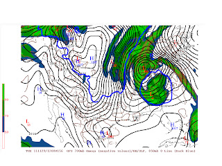
GFS Precipitation Type:
GFS 700mb Omega/SLP:

GFS BUFKIT Sounding KCLT at 156 (Tuesday 8am)
KATL Souding (Tuesday 4am):


No comments:
Post a Comment