Wednesday, June 6, 2012

Gradual Return to Warmer Temperatures On the Way. More Rain Chances Expected for Next Week.

If you have been outside a lot, chances are you are wondering: Where the heck is summer?  It feels more early Spring/Fall-like.  After the recent passage of the strong cold front from last week that featured the storms, that brought our temperatures down to below normal, allowing those highs to drop to more in the 70s instead of 80s or 90s.  Thanks to the solid cloud deck from earlier today, that prevented temperatures from warming up much despite getting into the eventual break out of the sun.

Don't get too used to it, because this will unfortunately come to an end as highs are progged to warm back up into the 80s and  possibly low 90s again later this week so hopefully you have been taking advantage of the cooldown.  With the return of the heat comes more thunderstorm chances in the offing as we get into the weekend and through at least the early part of next week.  Can't rule out some shower or storm to affect someone for the time being until that period comes.    

Wednesday, May 30, 2012

Another Day of Heat Before a Brief Break. More Showers and Storms in the Offing

About time that I managed to put in another update.  Thanks to having Memorial Day plans, not to mention getting used to a brand new computer I recently purchased (HP Pavillion G7 laptop), I could not be on here for updates regarding our tropical system Beryl.

Thankfully that will now be pulling away from our region and should be fully gone by tomorrow.  Rain still coming down a good bit along the NC coast so just one more day for them before it's all said and done.  Plenty of welcoming rain to go around for folks so no complaints there, although extreme southeastern GA and especially northern FL got whaled on with several inches!  Too much of a good thing, as always the case in the situations.

Tomorrow may feature some pretty hot temperatures as well across the region.  Some folks across the Southeast may experience low to mid 90s for highs.  Terrible stuff but thankfully by the Friday-Saturday period the weather will feature a nice break from that as highs get knocked by down into the upper 70s to mid 80s, plus those days also feature very good shower and storm chances so that will make for an even greater relief effect if you get caught underneath such.  For next week, those highs go back up into the 80s to low 90s again later that week but at least by then it will be the beginning of early June so it's fitting for meteorological summer.

Have a great day folks!    

Thursday, May 17, 2012

A Seemingly Drier Outlook to Round Out the Week. Coastal Low Effect for the Weekend? Warmer Temperatures Returning.

What a soaking few days it has been.  Several rounds of showers and storms occurred for many locations for the early part of this week, especially for the Carolinas.  Reports of 2-4 inches of rain were accounted, as I figured there would be based on what modeling was suggesting late last week.  Absolutely terrific for those who were in dire need of the rain to be relieved of the drought.  There is still some action occurring right now across parts of the Carolinas through southern GA, and that will likely persist for the rest of tonight.

Things finally appear to be drying out from Thursday, into the weekend, and beyond.  However, across the Carolinas and Eastern GA, it seems that more showers and a few storms may be in the cards for today but elsewhere it appears dry.  The weekend looks okay as of now but eyes will need to be kept on a developing coastal low that could bring some rain along the Eastern portions of the Carolinas for the weekend and maybe back further west but for now I will say it looks more dry than wet.  Warmer temperatures also seem to be making their comeback so now a range somewhere in the 80s looks to make a return instead of what we have been experiencing as of late.
  

Wednesday, May 9, 2012

Not As Warm Over the Next 7 Days. More Opportunities for Showers and Storms to Come. Potential Major Rain Event Down the Road.

Things have certainly been wet across parts of the region as showers and storms moved through, putting down some beneficial rainfall so thankfully, the increased chances for rain did come to past.  Some areas, such as Charlotte, finally received the first true rain event after remaining dry for quite a while.  Luckily we appear to have more chances on the way as we get into the weekend and through next week as well.  Temperatures don't look to be as warm (70s instead of 80s-low 90s) so things should feel more comfortable across the Southeast instead of dealing with early Summer heat.

Long-range suggesting the development of a cut-off in the Southeast sometime next week, which holds potential to put down some serious rain totals and if that were to verify, it will definitely aid in drought relief where it's needed (talking 1 to possibly 4 inch rain totals) per recent runs of the GFS.  Nothing in stone yet but bears watching over the next several days.


Wednesday, May 2, 2012

Back in the Saddle Once More. Late Spring Heat on the Rise with Shower and Storm Chances

Finally getting back to blogging again after a very busy few weeks with plans and such so I apologize for the lack of updates.  I'll try to cover all that I can regarding the rest of this week into next week.

If there is a time to start considering how much you'll be using the AC, now would be appropriate as highs are looking to keep pushing through the 80s and even some locations getting into 90 degree readings for highs for the rest of this week.  As far as rain chances go, we currently have a system going on back west that will be throwing back plenty of showers and storms through the rest of today and into tonight across MS and AL. There doesn't look to be anything overly-impressive as there only appears to be a general 20-40 percent chance for most locations (save for a few that stand at least a decent chance) as we finish up this week, which is going to make drought relief hard to come by where the rain's needed most.  For the Carolinas, the rain chances don't really show up until the weekend (excluding some mountain locations) while places further west will see potential from tonight and through Thursday.  By next week, the heat (and unfortunately rain chances) look to continue, at least through the early part.  We'll see if we luck out with getting increased chances for showers and storms to keep the heat in control but as of now, it looks like Summer is already making its visit to the Southeast for the time being.

Stay safe and stay cool.  Enjoy the rest of the week.  I will probably go back to doing these weekly updates unless something major appears (e.g. severe outbreak) to be in the works, which in that case there will be daily updates. 

Monday, April 9, 2012

Beautiful Weather for the Week With Yet Another Big Cooldown During Mid-Week. Then Warming Up Again

Not much to really say for this week considering the dry look across the Southeast for much of this week.  Highs look to get from the upper 60s to low-mid 70s for today and tomorrow.  By the middle of this week, however, another blast of strong cool air will push into the region and that will drop the temperatures down quite a bit compared to what we have been seeing.  Some locations across TN and NC on Wednesday may only get to the low 60s for highs with lows backing off into the mid-upper 30s, and that looks to be the case also for lows on Thursday morning.  This also means folks across the mountains will be dipping to freezing again with gusty winds as the cold front transitions southeast and departs from the region so it will feel chilly up that way.  Eventually we will warm back up as another ridge builds in and highs return into the 70s and 80s for the rest of this week.  Other than the slight chance of showers and storms for locations further west, mostly everyone should remain dry as it stands now.

Take care and have a good day.  Hope your Easter celebration went well.

Sunday, April 1, 2012

A New Month with Significant Warmth in the Works for Early Week. More Shower/Storm Chances Through the Week and Then a Cool Down Toward the Weekend.

After having a few storms erupt with a bit of an attitude in some locations across the Southeast, things are finally beginning to quiet down for tonight.  We should return to drier conditions for at least today and on Monday.  Highs on those days could push into the upper 80s to around 90, which will be a first for some this year.  I suspect if temperatures do warm to such, we could be having it flirt with or reach the 90 degree mark and possibly tie or break records.  Definitely not early April-like weather.

Later in the week, shower and storm chances should increase some so that will be returning into the picture but temperatures will not be as warm so its more like what we have been experiencing (70s to around the mid 80s). There is indication that by Friday, cooler air will filter into the region and some places will see temperatures back off some, especially for some locations across the Carolinas where highs may only get into the upper 60s to low 70s, which would fit a more Spring-like feeling instead of Summer.  Of course, that will already have affected places further west toward spots like Jackson, MS by mid-week with only the mid-upper 70s for them.  

Tuesday, March 27, 2012

Lovely Weather Through the Week. Isolated Chance for Showers and Storms Midweek with Better Chances for the Weekend.

Quite a cool-like day compared to the massive warmth we have been experiencing.  Locations across those who were affected by the dry canadian high providing the cooler air, mainly the NC folks, experienced temperatures only getting into the 60s instead of the 70s and 80s that have been a part of our weather for some time.  Tonight the lows will drop down into the 40s and back up into the 70s to around 80 tomorrow in those same areas as the warmer air will push in from the west while the rest of the Southeast will continue to experience the ever-persistent warmth.

A weak cold front will slide south with time and bring a chance of showers and a few thunderstorms up in the Appalachians and TN for tomorrow but only expect isolated at best east of there for Wednesday night through early Thursday.  We remain dry for the most part across the Southeast until the weekend with another system that holds a little more promise for rain and some storms as well for the weekend.        

Tuesday, March 20, 2012

Same Old Song Throughout the Week. First Official Day of Spring is Here.

I don't expect much change throughout the week across the Southeast as we should remain quite warm with a chance for showers and thunderstorms throughout the week each day.  For areas further west in the region, those chances increase some so places across AL and MS for example stand a better chance for such activity.  Highs will continue to remain generally in the 70s and 80s for the rest of this week.  Just keep an eye on the sky (and radar) each day if you plan to head out.  The pattern represents that of what we typically see during summer afternoons and evenings so this is quite unusual to jump into such so early and during March of all months on top of that.  Might as well be calling today the first day of LATE Spring with this kind of behavior featured in the pattern.  Almost makes me dread Summer but of course as everyone should know, what happens in Spring doesn't necessarily translate into how it is toward Summer (e.g. a warm Spring that becomes a cool Summer).  We'll see once we get into April and May but here's to rooting for a less brutal Summer in the distance future.  Would hate to see a repeat of consistent 90 degree heat rear its ugly head  with little to no relief.

Monday, March 12, 2012

Increased Chance for Showers and Storms Tomorrow. Big Warmth Still on the Way with Another Shower/Thunderstorm Potential for the Weekend

Today is only the beginning of what will be really considered a warm pattern as highs will be in the 60s and 70s with clouds and showers on the increase.  A few thunderstorms may occur in spots later today but I expect an increased chance of some sort for tomorrow for the folks further east so it's moreso than my previous thinking, which makes this look like a 30-40 percent kind of deal now.  The showers and storms should eventually pull out for later tomorrow and allow for things to clear during the nighttime hours.

After that system departs, highs still look like they will soar well into the 70s but now it looks like low 80s could be in store for more locations on Wednesday.  This warmth will last for the rest of this week afterwards and at least into early next week with another chance of showers and storms over the upcoming weekend.  Spring is definitely making its appearance as if it already hasn't done so but now I'm beginning to wonder if Summer is trying to move into our region for an early visit...

Have a good day.     

Friday, March 9, 2012

Back Again In the Saddle. Rain for the Overnight and Early Day Friday Period. Clearing Out for the Weekend with Cooler Temperatures and then Gradually Warm Up.

After much patience on getting a new monitor, I am back once more to update again.  I apologize for not putting out something for the previous severe weather threat, as that was around the time that I had officially lost both of my CRT monitors.  The new one is a Samsung SyncMaster 710N flatscreen.  MUCH easier to handle with more room available.  No wonder no one seems to manufacture CRTs anymore...

Rain will push through our region for the overnight and throughout the early portion of Friday.  I suspect that everyone clears out by the afternoon and/or early evening with cooler temperatures; likely earlier the further west you live from the cold front.  Highs backing down a good bit into the 50s and low 60s for eastern folks on Saturday but again areas further west will have already felt the effects of the passing cold front by then so they should warm up back into the 60s on the same day before places further east do. From there, it looks to remain warm and dry our eastern friends until the next system moves in, which will bring a chance of some fashion for showers and thunderstorms in places such as Nashville, TN and Birmingham, AL for early next week.  The precipitation may gradually dry out as it progresses further east to where it's just mostly cloudy skies or possibly even more sun but for now will go with partly-mostly cloudy skies with a slight chance of showers across areas for the Carolinas and parts of GA throughout the first half of next week.

Modeling indicating that highs could once again attempt to soar into the mid-upper 70s to around 80 across the Southeast later next week so we'll see if that comes to pass.  To be honest, it kind of scares me to see us already warming up so much in March, but of course if you recall from 2010, some places saw mid-upper 80s to around 90 for highs during early April so it's not impossible but definitely above average for that time of year.  I won't go into detail regarding what Summer could hold just yet but hopefully this is not a precursor to how hot it may be for the next season.  Until then, I'm glad to be back once again and hopefully this new monitor won't burn out or have any other issues before then. You all (including myself) can thank my 8th grade math teacher from middle school for making this possible.  He just happened to have a spare one lying around and decided to just give it away.  Just goes to show that there are still plenty of kind folks out there in this day and age.

Have a great weekend and I will update if any big changes arise for next week.

Wednesday, February 29, 2012

More Severe Weather Potential for Later Today. Substantial Warmth in Temperatures Before Cooling Off Next Week With Perhaps Maybe Round 3 for the Weekend.


Once more, we appear to come across a scenario regarding more potential for the development of severe weather across the Southeast.  Latest data suggests that the ULL will cut across the OH/TN Valleys, setting the stage for areas further south with the approaching cold front.  Temperatures should warm into the 60s and 70s for highs with some indication of instability and moist airflow, which according to the most recent run of the NAM shows low to mid 60 dewpoint readings.  There will also be a LLJ (low level jet) that sets up, which will aid in bringing another scenario similar to the previous event with the strong winds in place and of course the possibility for hail could occur as well. Winds will once more be the primary threat above all else.  I'd look for the best activity to be for later portion of today, though there may be a few thunderstorms during the mid-late afternoon before the front pushes through.

After the system clears out, much warmer air will be in place for tomorrow with highs reaching the mid-upper 70s, and can't rule out maybe a few 80 degree readings somewhere in the region.  There may be some showers or even a few storms that threaten certain areas given the progged behavior of the front by modeling (which shows it going back north some) but other locations should remain dry and will allow those folks to get out and take good advantage of that.  Afterwards, Friday and Saturday appear to feature yet another round of showers and thunderstorms with temperatures backing down toward the upper 60s to around 70 (50s to low 60s further west) until Sunday.  At that point, the second cold front will have pushed through and temperatures will fall into the 50s to low 60s for highs for the rest of the Southeast with Monday being the coolest day but should gradually warm back up again for the latter part of the week.

Regarding that second front, setup for that particular threat looks similar to today's event but with an enhanced risks of a few tornadoes given the progged strong shear and instability in play so we'll see if that continues to be a concern down the road.

Have a good day.


Friday, February 24, 2012

Severe Weather Potential for Today with Continued Warmth.

Keeping an eye on the approaching cold front back west as that will work its way across the Southeast for today.  The front appears the feature the possibility for strong/severe thunderstorms to develop through the day. With the warm and somewhat unstable airmass in place out in combo with a nice moist flow out ahead, this will set the stage for the activity as it pushes through.  Concern at this point appears to be mainly strong winds with some hail and given the look of the shear, I also can't rule out some isolated tornadoes thrown into the mix so it all bears watching for sure.  The further we progress through the afternoon, chances appear to increase as storms are progged to pick up a bit of speed while developing into a more linear-look, and with any bowing could yield stronger wind potential so please do be prepared if this is the case, as I estimate the winds could reach around 60-70 mph at their strongest gusts.  Highs appear to once more soar in the 60s to 70s so this will only further benefit the storms.  Keep tuned to your local weather and/or news channels, and of course that includes the weather radio if you have such, and keep an eye on the sky as well.


Monday, February 20, 2012

Clear Skies Today with A Nice Rebound in Temperatures Through the Week.

What an interesting event it was for many across NC as the system moved through, spreading snow for the first time across the state outside the mountains.  As expected, there were winners and losers with this one, and unfortunately for the folks south of I-40, little or no snow accumulation really took place like I forecasted (actually most of the predicted totals besides my thoughts on it were lower), though I can say that some folks did indeed see flakes mix with sleet or saw a brief period of snow fall, which allowed a trace to be reported for certain places such as Charlotte.  This and other areas who managed to report both the snow and accumulation of some sort are now out of the "No snow/measurable snow" idea for the winter.  Good deal. The problem with the event overall was the fact that the system did not go as far south as I had figured and moved a little more quickly, thus cutting the length of time that it would stick around.  In fact, by nighttime, skies were already clearing but as always, there are curveballs thrown somewhere down the road and this storm proved that such can happen.  Another issue was the fact that the system's moisture stayed more north rather than wrapping back into NC, putting much of VA in the game aside from northern NC and despite the small redevelopment back in SW NC, that never really made it further east later that evening but thankfully a spoke of energy that was gathering near the GA/SC border earlier that day that made its way here and provided the rain to sleet event for places such Gastonia. With that, this made me decide to NOT put out a final call map, as it looked like the preliminary was safe enough to stick with and make it the official one instead.  I'm thinking this is the last shot at winter weather, unless the end of this month brings something according to GFS, which right now looks more wet but could trend wintry and if not that, then MAYBE something in early March.  Who knows...

Temperatures will feel really nice as we push through the week with highs gradually going from 40s-50s to 50s-60s and can't rule out some 70°+ readings for highs on Thursday or Friday.  It looks like some shower activity will be arriving as we get through the mid-late week period, increasing in chance over time.  Parts of TN looks to get some showers here and there through the week but slight chances at best until later as it stands now. Could change toward a drier scenario but overall it looks nice and dry for most despite the shower chances.

Saturday, February 18, 2012

Update on the Upcoming Winter Storm.

The trend has been our friend over the recent runs of the modeling.  Many now suggesting some light accumulations reaching even down toward the Charlotte area.  Our system is currently residing in the vicinity of the LA coast and should be ready to make its way over to our region sometime later in the evening or tonight with the initial band of rain spreading in.  This system will eventually find itself redeveloping near the coast after seemingly disappearing in the region, and colder air will be filtering in quickly (with aid from a decent high pressure in the GL) for CAD development and will allow generation of a good bit of snow as it mingles with the storm.  As it appears, everyone seems to start as rain (though the mountains may start as a mix or snow at the highest elevations) but then gradually mix with sleet and/or snow and become snow as we get in the later part of tomorrow.  It still appears that the northern vort that I mentioned previously continues to look interesting as it would become the upper-level feature and should it develop nicely and take a good track while being on the backside of the southern vort, there may be deformation banding setting up somewhere across the state and anyone underneath it would likely see locally heavier snowfall and possibly heavier sleet as well. As you all know, these types of features can be a headache to try and forecast so my confidence is low on exactly how that plays out but if it were to cut-off as it went over the Carolinas, it could be VERY exciting but not jumping on that bandwagon just yet.  Waiting to see if we can get it right with that one but chances are if such verified it would mean re-thinking on what I believe could be the snow totals out of this, and speaking of such, I have created my preliminary map of it.  Again, just like my last map, several things can make this call bust on either side so it may be a snow-go or no go (leaning more toward potential higher amounts with the good trends).  Focus on the low end of the scale for conservative reasons for now:


We'll see how radar trends go through tonight and tomorrow but I have increased confidence that this will be the first flakes for many and likely the first accumulating snow outside the mountains for once.  Despite being but several hours away, there is still plenty of time for a change or two to go in our favor for the areas further south in the state but at this rate, the trend will probably be a tad more snowy across the southern piedmont (and yes maybe the extreme Upstate SC area) but the key term of this post is just that: Trends and nothing more.  I will put out another update if it looks like snow accumulations will have to be notched upward and if things really go our way over the next few hours...Take care and be prepared.
  

Friday, February 17, 2012

Carefully Watching the Weekend Storm Evolution. Perhaps a Bit of Snow Outside the Apps After All???

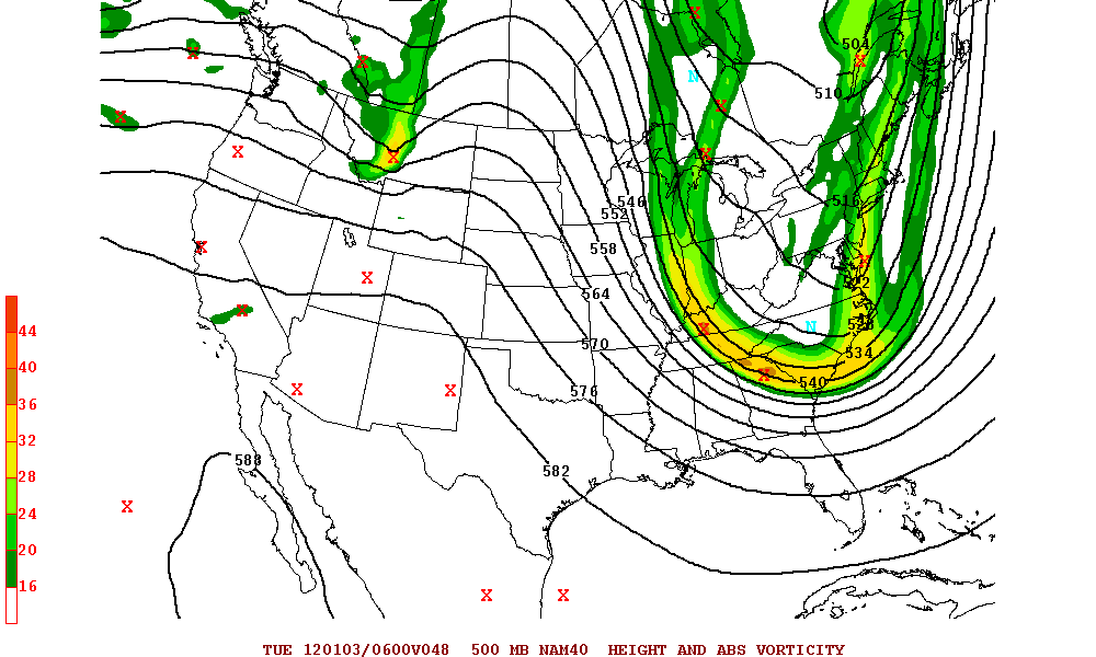
Model trending through much of Thursday has peaked several folks' interest once more after going through two days of less than hopeful solutions for anyone outside the NC Apps.  Recent output from the NAM, for example, shows this event going from initially rain to light snow or flurries as it begins to get colder on the backside of the strengthening system.  Another one, the 21z SREF, shows a nice period of wintry precipitation for parts of NC (and yes both of these are giving the Charlotte area some love for light snow or flurry action).  Canadian and UKMET remain with their solutions so not much change on them.  Euro for tonight has trended colder and wants to give much of TN, extreme northern MS and AL, and most of the northern half of NC a few inches.  Another southward shift or two with a solution like that and it could mean giving the southern piedmont and foothills something more than what I'm thinking but definitely not ready to say that will happen just yet, as I am skeptical of such a big shift right now but will not eliminate the possibility that as we get closer that we may have some form of "February miracle" here with this storm.  Specifically speaking for NC, it does appear that for the folks along I-40 and especially as you head north, some accumulation of snow is possible overall.  For areas just south of I-40 and on down toward the NC/SC border, at best I would say trace to perhaps 0.5" accumulations would take place given the longevity of the period of backside light snow and flurries.  Bear in mind, those are just simple thoughts about what I believe would be the case right now; NOT a forecast.  If the trend continues to look like a snowy hit is on the way after all, I will put out something either later today or tomorrow regarding totals, though it may more than likely be sometime Saturday for conservative reasons.  One thing is for certain, and that is this threat is still up for grabs and it can easily trend toward the colder/wintry side or take a last minute jog back to the more depressing looks but we'll see.  All options are STILL on the table at this point.  With all the moving parts involved, there is no lock of any sort even being only 2 days away. What we want to see are the following for a more southerly track and colder look:

1. The northern and southern streams to stay separated from each other back west.  If we get a phase going on over there, it will mean the system tracks further north and it will be all rain or little wintry precipitation. Thus this will allow the system to remain left alone to go more easterly vs. NE or north and then east (e.g. track through the Apps, Central Carolinas, etc.).

2. Going back to #1, with a scenario like that, this will mean that the area of high pressure, one that's strong enough, will be able to set up further east somewhere across the Great Lakes and push the colder air down, allowing it to establish itself ahead of the storm.  If those streams phased, the high would not be able to situate itself in a good spot and fail at providing a bit of cold air.

3. As you may have heard several times, the all important 50/50 (Newfoundland) low needs to be in the right place and at a good strength.  If it's too weak and/or in a bad position, we will get no aid from it and this will also cause the system to track further north as well.

4.  Assuming the above listed things set up for something favorable, the energy involved in the northern stream (after splitting) will involve one of the pieces becoming an upper level feature behind the southern vort.  With that splitting process of the northern stream energy, this means that it will not be able to shear the southern stream and weaken the system while flinging it northeastward.

And that's only the short version of how to summarize what needs to be analyzed.  There is A LOT more detail that I could have went into but decided to keep this in layman terms for those of you who are not as familiar with the meteorological techno-lingo and such. As you can see, it all needs to come together correctly if we ever hope to see a bigger shift with the snow threat so unless you live in the areas I mentioned where it's most likely to snow and receive decent accumulation, it's limited the further south you go in NC. Again MUCH can and will change, as they say, over today and probably a part of tomorrow if my assumption is correct with the model behavior.  Also will make note once more that I do think at this point, there is a chance for some backside snow showers or flurries to occur but again can go either way from tonight and beyond.  Could this be the first time we see a winter hit of some kind?  Will things trend in our favor toward the snowy side of life in an otherwise miserable, agonizing winter?  We can only hope and that's all there is to it. Pray, hope, do the snow dance, whatever it takes to bring good mojo for us (And of course I send out my optimism to other folks in the Southeast who are in a favorable spot for seeing potential snowfall.  Tonight's Euro already proves that potential is possible).

Until then, take care everyone!  May this be the one time that we actually see a winter event....       

Wednesday, February 15, 2012

Warming Up for a Bit with the Next Chance of Rain for Wednesday Night/Thursday. Still Watching the Weekend Threat.

As many had feared, the Valentine's Day event did not pan out so well in the snow department.  There were reports of a few flakes or brief light snow mixing with sleet and/or rain (or just plain sleet) but no accumulation whatsoever from what I've gathered. We had the moisture and temperatures were coming down some but not enough to allow a good kickover to snow across the Upper Southeast and put down totals like what some folks, including myself, were thinking.  This goes back to what I said previously, and that was despite how it may have looked before, things can change on a dime and unfortunately it was on the bad side.  However, the NC mountain locations did decent as expected with accumulations ranging from a dusting to 2".  Here are a few totals that I gathered:

Cullowhee: Dusting
Highlands: 1"
Macon and Clay county areas: 2"

Next system will be an all liquid deal as a round of showers should push through later Wednesday into early Thursday thanks to an approaching cold front.  The rain could be heavy at times and there is some indication that there may be a few thunderstorms thrown into the mix but not really expecting to see much of that as of now.  Behind that, we'll see drier air push in and knock the temperatures back down again after being in the mid 50s to 60s for highs for a few days across most locations but not much of a cool down though.

Model waffling continues with the Sunday/Monday threat as it appears that every model is handling the upper air pattern in some sort of fashion.  There is no clear cut indication on what the final solution is going to be, as the energy that's flung about is making it rather difficult to pinpoint anything.  Here's what I've noticed from each model that I've looked at recently:

  • GFS has been constantly changing in some fashion and so it has been very inconsistent.  At one point, it's 0z showed a NC snow special to hardly anything on the 6z to a rain event of some sort on the 12z.  However, from that point and through its 18z and 0z it still shows that system cutting more inland and through the Carolinas with heavy rain and so we'll see if it keep staying on this idea in future runs.  Need to see a stronger 50/50 low and probably aid from an additional area of high pressure in good position and strong enough for the cold air to mingle with the moisture and keep the system further south overall for this model.  Even then, this still became the outlier of the 0zs and so will not be concerned with this one at the moment (though it still stands a chance of verifying to an extent).  
  • The Euro has been wanting to bring in the system further inland on its past few runs, causing our temperatures to be a tad too warm for anything wintry. There was indication of a big hit of snow across the entire western half of NC on one of its 12z runs but has abandoned that idea up until tonight's 0z, which shows a bit of accumulation across the NC mountains but no one east of there.   However, the past two recent runs after the small north shifts have pushed this further south and getting a tad colder so we'll see if that's a trend in the near future.  It actually seems to nearly match up with what it depicted back when the storm was 10 days away so that was interesting on its part. 
  • CMC has been adamant on a system that bombs as it heads into the Atlantic but unfortunately wants to show it cutting inland some through southern GA and SC.  Right now it advertises rain but could be enough cold on the backside for a changeover to snow or a mix for a short period across portions of NC.  Would not expect much, if any, accumulation if that were to play out with a scenario such as this and likely this is for the northern half of the state and into southern VA.  Only needs to trend colder.
  • NAM has been very consistent on a healthy system that traverses along the Southern US states (at 84 it's around the NM/TX areas) with a good 1027mb high pressure (a tad weak) but just enough to aid in supplying colder air.  Will be interesting to see if it can keep this up.
Overall, you can pretty much tell that we have a LONG way to go before we can even begin to feel confident on something here.  There are many details that need to be ironed out and to be honest, I suspect even more waffling when the shortwave energy finally gets sampled (if it hasn't already).  Hopefully as the week pushes on we will see one of those cases where we have a storm, lose it in some way, and then bring it back within 2 or 3 days before the date in which it begins.  We haven't had one of those yet as this winter seems to want to advertise a threat and then eliminate it through a very weak/dead system or one that didn't feature enough cold (ala this recent event) for widespread snow. If we start to trend better, then it will be the FIRST TIME this season that we have seen a threat hold UNDER five days.  No more 7-10 day outlooks, which is a good sign but we need to keep this up.  In this case, I would not be anymore disappointed or excited about this compared to the past few days since we can't seem to get a consensus here on what plays out but all that I can really say is to keep watching.  It may not be until sometime Thursday or heck even Friday that we can safely say what will be happening but remember:  Just like this recent event, it can all change on the day of its arrival and so that needs to be kept in the back of your mind (and mine as well).  It's going to be quite a roller coaster ride with this one so hang on.  

Take care everyone.


Monday, February 13, 2012

More Valentine's Day Storm Details. Continuing to See An Interesting Event for Next Sunday. Will It Happen...?

All eyes for those who stand a good chance of seeing some frozen precipitation are watching as the storm continues to develop and push forward.  Snow and wintry mix events have already occurred across portions of TX and OK, and this activity will shift into AR next during the early morning hours today.  Some places across those states were not forecasted to have much accumulation but turns out that a few folks out there received an inch or two of snow and even some sleet managed to pile up a bit!  Quite a surprise for them and goes to show that despite how it appeared before the event began, anything can happen even on the day that the event's happening.  As for what is down the road across the Southeast region, the threat still remains that there could be a period of anything of the four (snow, sleet, rain or perhaps even a bit of freezing drizzle/rain) or a combo of some sort and any changeovers.  Much will depend on timing, the behavior of the precipitation, and of course the trending of the temperatures.  I'm still thinking that for the areas favorable, there may be some light accumulations across portions of TN and across the northern portions of MS, AL and even GA stands a chance, and of course up across the Apps.  Again, if such is desired, we need to see to it that this precipitation arrives earlier which will be much more acceptable since that would mean the precipitation will fall during the nighttime hours and with the additional cooling from the precipitation falling through the dry air (assuming it's enough), it should further allow a sufficient temperature profile to support anything frozen and last for a longer period of time.  Course, this may take a while to saturate the air but eventually frozen precipitation will initiate and reach the surface.  Not saying that is exactly what will play out but rather I am stating that is what the setup would have to be in order to pull this off, and honestly I do think this just may be the case as of now.  It still doesn't look like much further east into the Carolinas but in the western sections, the further west you are the better the chance you have that you may see a few flakes and/or sleet pellets during the early morning (and yes I think even areas such the Charlotte metro region could see a brief period of it) but don't expect any accumulation and likely temperatures will warm to where it's drizzle or maybe just remaining cloudy since the moisture is forecasted to eventually break up or dry out as it attempts to push further into the Carolinas.  What matters now is watching how that system behaves and how our temperatures are looking through the day today and into tonight.  With that said, here is my thinking on how much snow could accumulate.  Bear in mind, this will depend on a few things, such as precipitation rate, temperature, whether or not there is mixing present, precip. changes, etc. and thus can say that with any ice and/or rain can knock down totals on this map so try not to get too excited but as of now I feel confident enough to create this.  Also make note that when I say up to an inch for the light blue area, I'm referring to anything from a trace to that mark so not everyone may see an inch but it's possible that a few spots can get there.

Snow Map:


As for the other system next week, tonight's runs have been very interesting with this one. The Canadian, for example, has this curving up and along the southern East Coast (though it begins to move off into the Atlantic after leaving the GA/SC borders) bombing as it does so to 999mb.  Snow falls over parts of NC with some sleet further south and east of the state.  On toward the Euro, it is still adamant on a southern slider-style kind of system and is actually a bit stronger than what it previously forecasted (1006mb) as it crosses northern FL with 850s a tad below freezing.  However, while 2m temperatures are almost at that same point, it's not quite there but the model still insists on giving very light accumulations (appeared to be at least a dusting) for parts of NC/SC and then takes that system OTS.  Definitely still worth watching and of course, this run made quite a northern trend with the storm but as we know, it is better to see these type of scenarios be more suppressed and then gradually see improvement the closer we get so hopefully this does not keeping trending into a more inland kind of system but I believe that it will keep that system south and then maybe we may see good trending of it becoming more coastal and stronger with slightly colder air to work with.  Keep those fingers crossed!

0z CMC Precip Type:


0z ECMWF:


Saturday, February 11, 2012

Arctic Air Settling In with Persistent Windy Conditions. Few Flakes For Some Today with Snow Showers Across the Apps. A Few Details Regarding Next Week.

Man what a day it has been for many.  Early-day temperatures in the mid 40s have quickly fallen down into the 30s throughout the afternoon and with that some gusty winds will be around for the rest of the day.  Winds should gradually die down though as we get into tomorrow but I expect the occasional 30 (maybe 35) mph gust could kick up before then.  Some folks were lucky enough to see a few flakes escape outside the Apps, which does officially count as "seeing snow" of some fashion so the flakeless winter is ruled out for some but don't expect anything bigger than that if you happen to be standing in the right spot.  Snow will continue to break out across the mountains and with that WWAs and WSWs have been put out for the counties up that way.   Lows should be making a drive down to the 20s and teens with mountain spots looking at lower teens to single digit readings!  I can't rule out on upper teen readings for some further south in the Southeast so prepare yourself for quite a cold night.    We will likely remain quite chilly for a few days before warming back up some during the mid-week period.

There has been much talk of the supposed Valentine's Day threat, and if you are one of the folks that have been following this, then you are likely aware of the recent downtrend we are seeing with this.  If you want my thoughts on what I think could play out with this event, it's this:  While I do think that there will be some kind of wintry event that takes place across the upper portion of the Southeast (especially for those west of the Apps), it's hard to really see much of anything further east as the system's moisture becomes limited and the cold air out ahead of this appears to want to retreat before it gets into the Carolinas.  Now to be honest, I actually think that we could pull off a quick improvement of this system and may see something for everyone further east in the region (the favorable spots that is) but if so, this would need to happen early in the morning as temperatures will eventually become too warm to be anything frozen but will say that some flakes of snow or a mix of it and a bit of sleet is possible before it kicks over to showery-like activity (if any moisture left by then).  It bears watching but I really can't be too optimistic with such.  Beyond that, there's another system to watch (if you've been seeing the Euro) that would occur sometime during the 19th-20th time frame but being that it's way out there, I can't go too deep with that one but yesterday's (and today's) 12z both have a nice southern storm system that slides through with enough cold air in place for possibly a good hit.  We'll see.  I can relate with some of you that we would watch any threat, be it in the near or long term, with the way this winter has been.

By the way, I would have put up an update yesterday but had some issues with my original monitor.  Turns out that something within it has blown and is no longer able to show a display of anything so I had to swap out with another one that I had lying around and do a bit of adjusting with both my desktops.

Have a good day and stay bundled.

Monday, February 6, 2012

Wedge Wins Out for Those In NC for the Past Two Days. Update on the Potential Storm

Well I must admit despite how things appeared to be for our highs, it looks like if you happen to live in the wedge that set up, you are likely one of those folks who are struggling to get out of the 40s or maybe just barely passed 50 for highs today.  Yesterday was a similar story but there was quite a tight gradient in temperatures across the Carolinas.  Where it was in the 40s and 50s up north as you head further south temperatures were substantially warmer (someone reported reaching 80 for a high down along the SC coast)!  What a difference.  Clouds hang tough for a while longer, though some of us are already clearing out and we even managed to see some light showers/sprinkles occur across SC.

Regarding the upcoming weekend threat, it's still up in the air where we go with this.  Modeling has been coming up with different solutions; some trending drier but colder, some going with a rainy look (which is still my thinking unless this system ultimately gets suppressed), or if it's anything like the NOGAPS (Navy) model, the wintry hit but GFS has backed off from that since its 0z.  All of this appears to be highly dependent on how good our phase goes.  I made note of this yesterday about how it needs to occur and do so correctly in order to pull off a wintry hit here.  Otherwise, we get nothing interesting and will be forced to look on ahead to anything else that may hold some potential.  Here's what I mean.  Look at the 500mb chart below.  You will see 3 pieces of energy that's available.

18z NAM:


This needs to occur in a way that the system will become much stronger and will take a favorable track (GoM  right up along the East Coast) with cold enough air in play.  Also notice that this would be showing a potential Triple Phase which are VERY RARE and when such a process becomes successful it can produce quite a major system.  The March Superstorm of 1993 is a classic example of a Triple Phase scenario but I'm in NO WAY saying this is what will happen since odds are heavily stacked against seeing something like that again so soon but regardless, it's still interesting to note that this is showing up.  The more likely phase potential would include the bottom two and not the one that's far north at the moment.  Like I stated earlier, there is much colder air that looks to come down for a while, which most modeling seems to agree on but with the northern stream being so dominant, the system can't pull further north.  Now I suppose that the GFS could be playing its typical bias by having systems too far south due to being too strong with the northern stream but that is just wishful thinking on my part, as this go around could be an exception.  As with all phasing potentials, timing and location will be very difficult for modeling especially when you take into account the current behavior of the pattern so much will likely change over and over again for a few days on all the specifics.  We probably won't get a better handle on this until around Thursday I would assume but not holding my breath for it just yet.  Just keep watching and if anything changes (good or bad) I will update again.


Sunday, February 5, 2012

Rain Winding Down Through the Morning. Still Watching February Pattern with A Potential Interesting System

As of this post, the last bit of rain is just now pushing through the Carolinas with areas back west already clearing out.  There are still a few lingering showers in some spots but I expect a gradual drying solution throughout today.  Highs for today should range in the 50s and for a part of this week before we warm up a bit. Not nearly as warm as we were for the past week with those 60s to around 70 but still pushing at least slightly above normal for some; others staying around seasonal.  We should remain dry for most of the week but there could be a few showers for portions of the Southeast on Friday but not too concerned with that at the moment.

We're almost done with the first week of this month, and already the potential pattern change still looks like a possibility at some point.  If such is to take place (and hopefully so), I would expect it to be sometime either during mid or maybe even the late period of the month.  Of course, one should be aware that the further we go with this, the less time we have left to get in on something before winter is officially over but it's not impossible to get snow even going through late March but that takes a VERY lucky setup to get snow at that point, let alone accumulations.  The latter portion of the previous week and throughout this new week will put a strain on how models handle the overall look of the northern hemispheric pattern so I expect some flip-flopping to continue for a while. Recently however, we seem to be noticing the MJO (Madden-Julian Oscillation) forecasted to actually get a move on for once, which is set to go into Phase 8 (good if you like cold).  No guarantees yet on this but it is encouraging to see such being depicted but the question remains as to whether or not we can get a strong signal into Phases 1 and 2 or does it die off before then.  Also the possibility for the NAO to head into the negative territory has been popping up every now and then so that bears watching if we can just get the Greenland ridge established, especially since we finally have our AO in the negative phase and of course, the +PNA has continued to be advertised over the next several days but we still need to see to it that it develops and positions itself correctly for much of this month.  I will continue to watch how it all unfolds but right now the full-blown change is only at the potential stage so nothing set in stone yet but the chance is better than it had been for December and January and if so, we may actually get in on much colder air; one that actually lasts longer instead of being a quick shot.

There have been signs of the next system, especially per the recent GFS and its ensemble mean, that we will get a gulf low that develops and tracks itself in a way that would be favorable for a nice winter storm event. The model has been showing this for quite a while but tonight's run has truly began to peak my interest, for it was quite a close call with something. However, temperatures are not quite cold enough as of now but the trend has recently been for this to inch itself closer and nearly mingle with the storm for the Southeast on some of the latest runs so we will see if we can continue that cold trend.  To complicate matters, there is also potential that we can get some sort of phase going on (and we all know how difficult that already can be on modeling).  Right now, my confidence is rather low on what plays out but if I had to side with something, I am leaning on just a plain rain event at the moment unless things change and we do end up seeing a better chance at something frozen.  The Euro has flipped quite a few times on its part with temperature and has gotten to the point where it doesn't have the storm as of its 0z but has attempted to push colder air into the Southeast so it's a battle between it and the GFS.  We need to see that cold build in more quickly and deeper before the system gets its act together if we want to see anything frozen with this one but right now I really can't say how good our chances are with this. The good news is that this is within a week instead of around 10 days or more out so we have that on our side but that means room for improvement will decrease the closer we get and in that case, we would like to see the colder trend pull through over the next 2 or 3 days.  Course, this also means that we still need to have our system take a good track instead of staying too far south or weaken/die off. Can't say I'm too optimistic with this but we can only wait and see what models have to say about this once we get through most of this week. Could be rain, could be a nice wintry hit, could be just dry.  Who knows? We're all playing the Guessing Game here...

Take care everyone and stay safe. 

Sunday, January 29, 2012

January Winding Down. More Warmth with Showers Later in the Week and Turning Cooler. February Miracle Potentially on the Way...

It's been warm for a few days as highs pushed from the upper 50s and throughout the 60s (for most that is). Some have even flirted/barely passed the 70 degree mark for the folks further south.  Unreal for late January. Definitely has not felt winter-like around here but at least, as expected, we dried out after seeing consistent rounds of rain and even some thunderstorms thrown into the mix.  Things look to remain dry for the first half of this week before we get into more rounds of rain during the second half starting sometime during Wednesday and into Saturday but only a chance at best so nothing completely certain but there could be showers here and there for some.  Temperatures look as if they will continue to be in the range that we have seen them stay in for much of this week before cooling off for the weekend.

Medium-long range has remained quite interesting with our pattern.  There has been agreement that at some point during early February we will begin to build a nice +PNA (western ridging) that extends throughout Western Canada.  During this time, we also see the AK vortex FINALLY get booted (one of the main culprits behind our terrible pattern) and with that said this will set the stage for what could be a pattern that features a longer-lasting cold scenario and possibly be able to track our first real winter threat for the Southeast.  Tonight's Euro, for example, showed what I am talking about and develops a trough across the East but this run came very close to showing a decent winter storm for some across the Southeast, though it actually prints out snow for areas such as the Carolinas but it's quite light so not much but still interesting to note.  The point in all this is that the pattern change is looking more and more likely to occur and for once we are not simply losing the solution in a matter of 2 days, as it has been a fairly consistent one over the past few days now.  There is still a great deal of uncertainty as to whether or not this materializes but if it were to do so then we could be heading into a fun month and possibly beyond through a part of March assuming that it is not a transient change.  We shall see...

Monday, January 23, 2012

Temperatures Seemingly Trending Warm for a While with Chances for Showers/Storms Through the Week. My Thinking for the Rest of Winter.

Back in the saddle again after much work and will be able to update again.  I apologize for not being so active for the past week.

Severe weather continues to be an absolute menace to our friends back west across MS, parts of TN and AL as a strong cold front pushes eastward carrying with it continuous threats for strong/severe thunderstorms with a few embedded tornadoes.  Looking at some of the hodographs earlier, they were very scary looking and would suggest significant shear to aid in the spin ups.  Despite it being the late night/early morning period, the line still holds strong and will threaten areas further east later on.  Hopefully anyone over there has been keeping an eye on it.

Severe threat should diminish some as it gets closer to the Carolinas and GA, though I won't rule out that a few of any of the storms that do develop could get a bit of an attitude.  The latest from SPC issued a slight risk for portions of AL and GA up to around the Southern Apps, which fits my idea of where the best area of storms could set up. Greatest threat appears to be strong gusty winds with any storm so we will need to watch that for some folks.  There may be an isolated tornado or two to watch but I don't think anything like what is currently going on will be the case thankfully, as the trend has been to weaken the storms to a less aggressive level as it stands now.

From the looks of things throughout this week, there appears to be plenty of shower and storm chances to go around for much of us but ranges from about 40% to 70% so not everyone may get in on the rain.  Not looking at a major washout nearly everyday for everyone but it could remain damp if the showers and storms materialize as indicated.  We may be able to squeeze in at least two dry days though before we get through the rest of this week.  As far as temperatures go, it appears that they may (keyword "may") finally get onto the warm side with a general range of upper 50s to even upper 60s at some point but I do think that we only stay like this for a while before cooling off again as we close out the month and get into February.  Looking back at the previous runs of the modeling for the last few days of the previous week into the early part of this week, highs were advertised to be much warmer than what actually verified.  In fact, for my area, I have went 5 days in a row below what was forecasted with 40s being the readings and yesterday getting stuck in the mid-upper 30s thanks to a CAD that settled into place.  Just goes to show how influential those setups can be on our temperatures despite what you hear from the local mets or even from your NWS office in some instances.  With clouds and rain consistently in place, it prevented the warmth but that now looks to finally rear its head into view for this week.  We'll see how warm we really get with our highs but that is how it appears judging by the data.  Of course, I am not solely forecasting from just the modeling, as it has been said many times that nothing is set in stone with them and that there are other things that can just as easily influence our temperatures so we may see cooler readings than expected.

Also, if you have not seen my post on Americanwx yet, I will repost on here about my thoughts on how things could turn out for the rest of the season:

"I think I speak for mostly everyone when I say that honestly it's anything goes at this point. Modeling can only handle but so much of the pattern and for it to further complicate them based on its behavior and evolution makes matters worse, such as the flip-flopping that we continuously see in the medium to long range. Nature will do what it will do and no amount of wishing or hoping can change that. If the pattern turns for the better once we begin closing this month and get through the first bit of February; great. This means that all that we would have to worry about at that point are whether or not we get a storm system that times/tracks itself correctly to mingle with the cold and potentially produce nicely for some folks across the Southeast. If not and we still end up dealing with the stubbornness of this by the mid-late period of next month well that is just something we can't do anything about and would have to settle for it. I still like the idea of us getting into at least one major storm, likely in a scenario in which the pattern shifts into a more favorable setup for such (if we get can get it that is) and allow a widespread "major" snowstorm or wintry mix of some sort, though I hope that doesn't include a good bit of ice should it occur. I also would like to think that this pattern will break at some point before we get too far throughout the first quarter of the year but when that happens (if it does) remains in question. The point is, until we get rid of that pesky AK vortex and get the overall look of the Pacific and Atlantic to appear more promising (even something somewhat decent would be nice if nothing else), I would remain cautiously optimistic for the most part. Also, if you think about it (and this is going by calendrical standards of a winter season), it has been officially one month since winter started so we still technically have plenty of time. After all, history will tell you that even with a horrible Dec./Jan., it only takes a storm or two during Feb./Mar. to make an "epic" winter for the Southeast. We can only continue to have more patience from here on out and hopefully this pattern pulls a 180 in the latter."

Can't say it any better than that.  It is what it is and we will just have to wait and see if we can pull off a February/March miracle here.  There is always that outside chance...

Take care everyone and please be safe if you are one of the ones who were or about to be affected by the storms.  Always remain on the safe side of things when dealing with potential threats for a tornado.  Don't take chances and assume things in these sort of situations.  Not good in the latter if you do end up with something nasty in your area. 

Sunday, January 15, 2012

Jan. 14th Clipper Snow Totals. Rain Looking Likely for Monday/Tuesday. Where's Winter???

Here is yet another set of totals that I've seen from people who were able to get in on the clipper from last night.

Asheville, NC: 0.5"
Boone, NC: Around 2"
Haywood County, NC: 2"
Red Hill, NC: 2"
Yancey County, NC: 3"
Beech Mountain: 6.5"

Cold front will swing in for the early portion of this week, setting up the stage for plenty of shower action across the Southeast.  Ranges anywhere from an isolated to a good chance that it falls for some areas (30%-70%).  Should be out of here as Tuesday night progresses, and we get back into dry conditions once more with temperatures just a bit above normal for our highs.

Medium to long range has not looked good in the past few days.  In fact, given what most has shown, we may be talking about flirting and/or breaking records across our region with 60s and 70s for highs as a strong ridge is progged to build over us, keeping the cold air well at bay far north.  However, during this time, there is a chance for some good dumping of rain as a system is forecasted to cut-off to our west and progress eastward with potentially some nasty severe weather thrown into the mix but will not go into specifics on that just yet since this is way out there.  This period appears that it will begin by next weekend and last through most of the remaining days of this month.  Unless we turn downright cold and stormy for February and early March, I'm afraid that this winter will end on the warm side with average to much below average snowfall for most of us.  Of course, given my recent posts, the mountain folks are at least getting the white stuff, and that goes for a few of you who managed to see snow with the cut-offs from last year during the last few days of November and again during early December but nothing that would be considered a widespread major winter storm.  You may (or may not) have seen my post on Americanwx but I did mention how I was beginning to think that I should have changed my forecast to where I have us at or slightly above average in temperatures but eh what can you do.  Seasonal forecasting is extremely difficult especially in an amped pattern with several pieces of energy flying around.  There is no "persistance" regarding troughing/ridging in one spot for several weeks at a time and so this makes things fluctuate consistently with cold shots and warm ups with rain and upper-level systems swinging through.  It's a lot to handle for the models and thus things drastically change on a day to day basis regarding seeing fantasy winter storms or major flooding rains 10 days out.  Nevertheless, winter seems to be taking a vacation soon and who knows when (or if) it comes back for next month.  We'll see how it plays out.  Maybe we can pull off a 180 compared to the previous winter where it was cold the first half of February and then flipped the switch from Winter to Spring.

Have a good day everyone.


Friday, January 13, 2012

Update on Clipper System with Totals. Another to Dive In For Saturday/Sunday. Maybe a Few Flurries East of the Apps...?

Here are the totals that I've seen from this event.  There are a couple of areas that are still receiving a bit of snow as of this post:

Boone, NC: 3.0"
Beech Mountain, NC: 4.0"
Franklin, NC: Dusting
Haywood County, NC: Dusting
Unicoi, TN: 2.2"
Cullowhee, NC: Dusting
Leconte Lodge, TN: 4.0"

By the way, looking over at the WRF, it is showing yet another possible clipper for tomorrow, but this one may actually get some moisture on the east side of the Apps for early Sunday.  Will it?  Doubt the chance but you can never be too sure of these systems. Sometimes they are able to throw a curveball down the road, which can make or break for more folks to be able to see some flakes.  We'll see...


Clipper Event Winding Down. Strong Gusty Winds for the Overnight and Getting Chilly Friday.

Tonight's clipper proved to put down more than I expected, with some folks across northern AL and GA reporting a good bit of flakage so congrats to them. As you would believe, the NC mountains got in on some nice snowflakes as well but for anyone east of the Apps, that chance was diminshed a good bit as the drier airflow on the other side prevented anything that tried to come down on the other side, especially since it is notoriously known that the Apps "eat up" the precipitation.

Winds tonight seem to be quite nasty out there. Latest Wind Advisory information suggested winds could actually peak at 50 mph for some during the overnight (already a 35 mph peak gust here in Gastonia) so they may strengthen more it seems. Quite impressive but these winds should gradually diminsh as we progress through the early portion of Friday. Hopefully you had your loose objects secured or put away before the winds swept in, as I'm sure that if you are like me the trash can may have been knocked over or blown down the road...

Friday will be chilly as forecasted with highs still looking like it will be in the 40s and down into the 20s for lows but we will slowly moderate afterwards toward the 50s as we get into next week.. Not out of the question that parts of TN will be stuck in the 30s for highs so it will be quite a cold one for that day. We'll see how low we can go. Next chance of rain afterwards appears to be sometime around the Monday/Tuesday timeframe for much of the region.

I will post an update tomorrow on any reports of the clipper event posted on the forum for recording purposes. Until then, later folks.

Thursday, January 12, 2012

One Last Warm Day Before the Chill. Maybe Clipper Snow for Some Thursday Night/Early Friday? Major Changes to Modeling on the Pattern but Will It Last???

Yesterday was quite interesting regarding the storms that fired off during the afternoon and early evening.  If you happened to live across the Carolinas toward the western half and portions of north GA and southern TN, we had strong and isolated severe storms that developed with hail and winds (as anticipated).  Of course, we also had the one that formed in Spartanburg county and that quickly became a tornadic cell that eventually made several areas northeast of it be put underneath a tornado warning and on up into a portion of Ellenboro, NC.  Reports of certain structures collapsed, several trees down, and a few injuries came in as that storm raced through the Hickory area after departing from Forest City.  I will admit I only anticipated that with any rotating storm that the potential existed for a brief quick spin up of a tornado but this one proved to be more dangerous than forecasted.  Then again, you can never be fully confident on how strong these tornadoes can get once they get going since there are a lot that is in play, and today provided a nice example.  It was all about elevated convection with the low-topped thunderstorms that include strong upper-level dynamics and so despite surface temperatures being relatively cool, the strong/severe threat still kicked in.  Even folks in the mid 40s saw some rough storm action up toward the mountain communities (Wilkes county, NC was one of them).  Now I will also admit that this wasn't as big of a deal as I had feared earlier but it did not put a stop to some folks seeing around quarter-inch hail and winds greater than 60 mph, which by the way the cluster that contained the tornadic cell became a mini-bowing line with 70 mph peak wind gust.  Terrible stuff.  This is suppose to be January, correct?

This radar image was taken right around the time that the tornado warning was placed: 

Here's a shot of it when it was within the vicinity of Ellenboro:


That made headline news for the evening as several storm spotters/chasers went out to investigate this storm.  Lots of coverage went on with this cell as it continued on its course with the couplet holding strong for quite a while; longer than I imagined.  Scary stuff indeed with this storm and it even went out of its way to cause some people to be trapped in their own homes.  Bad way to start off 2012...

The ULL responsible for this action today will continue to trek away from our region but because it has stayed more on an easterly track before heading up the Apps than what modeling suggested and with the front pushing through the Carolinas, gusty winds look to be the conditions for the overnight hours for some and it appears to continue through the day Thursday.  Interesting to note that recent short-range modeling suggesting, perhaps, some flurries could be possible across the Upper portion of the Southeast during the nighttime hours Thursday into early Friday morning with the next incoming shortwave.  Nothing significant but there may be some flakes flying in spots but it will be hard-pressed to get anything east of the Apps.  However, there have been instances where moisture, under the right kind of flow, is available on the other side and puts downs quite a bit of flakes, enough for even an inch or two (ala Dec. 4-5 2010 event) but not betting on a scenario like that for now.  It would be in, out, and gone just like any other clipper (hence their name) for the NC folks.

The model madness continues with tonight's runs of both the GFS and Euro showing much different solutions than what has been showing consistently.  For the GFS, it had quite a warm look for much of the U.S. with no real troughing or ridging (zonal flow) but it has now decided to, once more, flip flop back to a colder look despite a few warm days thrown into the mix and teasing us with a system around Day 6 but it stays suppressed.  Meanwhile the Euro about a week from now wants to develop a nice -NAO with much warming over Greenland, which is very good news but it does not have the Alaskan block in a good spot (ridging is further west as opposed to being over AK) so the cold air never really dives south and east and instead stays mostly in Western Canada with the vortex.  I think there is plenty of room for improvement in the long run but it also leaves room for this to quickly disappear so don't get excited yet but these were good runs for tonight.  We'll see if it continues and it proves my point: Living and dying by models won't get you anywhere except down a path of frustration.  They are merely tools used to aid in forecasting, not the be-all, end-all.  It is after all called Meteorology, not "Modelology."  Can't stress that enough.

Take care all and keep the hope alive.  We are bound to get something out of this season sometime sooner or later as it stands now.

Wednesday, January 11, 2012

Possible Active Day Setting Up. Still Looks Chilly Through the Weekend. Model Flip-Flop Continues About What May Happen Next Week.

It was yet another cool and cloudy day for some across the Southeast yesterday while others got in on the rain with some thunderstorms thrown into the mix.  A few of those got a bit of an attitude back across parts of the Gulf Coast states (even now there are still some over there dropping a bit of small hail and producing brief gusty winds).  I expect that to be today's story as that system continues to march on, bringing that slug of moisture and storminess for the folks further east across much of GA and the Carolinas for today.  For now, we have scattered showers spreading over parts of the Carolinas and GA for the early morning period. 

It still does not, however, completely eliminate the threat for any of those storms to become quite strong or severe over toward the areas I mentioned.  As of latest analysis, the shear still looks strong with the current line that's in place along the attending cold front and as it heads due northeast, these storms are capable of producing more strong gusty winds and of course this includes the chance for a quick spin up of a weak tornado given rotation potential with any of these storms.  Take note that because of the timing of which this line in particular arrives and pushes in, chances of anything severe are kind of low but don't be surprised if you are underneath one of the nastier ones.

There is, unfortunately, another round that may come into play as the low itself pushes closer to the Carolina region and given the upper dynamics in play, this line could also be dangerous with possibly better chances for hail and strong winds taking into account of the track of the system itself and so this would be more for those generally anywhere across the western section of the Carolinas, northern GA and eastern TN later in the day since they will be within the dynamics but I will go ahead and say places just due east need to keep a watch on this too just in case.  It should be noted that with that batch of precipitation, rainfall will be quite heavy and for the folks across the NC Apps, flooding may be possible so keep an eye out on the creeks and streams up there. Currently there are areal flood watches issued for the mountain locations.  I will explain it in the next section.

Going over specifics of this setup, we have indication of strong upper divergence of the jet with rising air due to low level WAA (warm air advection) and of course with given the track of that system and its flow, there will also be air that gets forced up the eastern slopes (or SE upslope flow), which is responsible for those watches being issued for the heavy downpours that could occur.  Alongside all of this, we need to watch throughout the day how the parameters shape up as the system gets closer.  Instability is questionable since we have some data saying that there may be more available while others keep it in check and only provides little support from it but I'd take a blend of the two and say that it will be just enough to give a bit of hand to the storms.  Shear remains strong it appears with the low-level jet that looks to set up shop over the piedmont locations of NC/SC, which supports the strong wind idea.  We will see how bad it gets but right now anyone's game for this, even way out into the eastern areas of the Carolinas despite being further away from the system.


Behind that system and the cold front, drier air will invade and clear out things completely throughout the day tomorrow but much chillier air will spill in with it and it's still looking like some areas could stay in the 40s for highs over the course of the weekend after that air settles in.  Winds will kick up a bit as that front swings through during the nighttime hours tomorrow and into Friday.  We get in one more warm day during Thursday so make use of it if you don't enjoy staying out in the chilly air.

Now then, as for what may lie ahead for next week, modeling still doesn't have a clue about what may (or may not) happen during that time.  Latest run from the GFS, which completely erased the snowy hit that was suggested a few runs back a few days ago, now says that we have a minor CAD event shaping up with cold air that manages to makes it way down toward the Carolinas and precipitation spreading over it (albeit light). This has the appearance of the formation of a bit of snow but it also throws in freezing rain in the mix. Nothing major but a tad interesting to note from this run.  We'll see if that continues (odds as of now are not due to the flip-flopping of this cursed model) but who knows.  On and it off it seems to be with the 14th-18th period ever since New Years.  There was a lot of cliff diving after we lost the snowy hit but keep in mind: NOTHING IS CERTAIN.  Meteorology will always feature that when dealing with unpredictable systems, especially those that develop during winter and even moreso when it involves the Southeast but alas that's our luck.  Just have to keep watch on anything is all I can really tell you.  This can either become a surprise event or nothing at all. Simple as that.

Well that should do it for tonight.  Hopefully the severe threat doesn't grow too much but hey if you are a believer of that old wives tale (thunder in winter; snow 7-10 days later), you may be rooting for it haha.  I'll admit my guilt with that for I believe in it as well, though there has been proof that the relation does exist, albeit it's 70% of the time so it is not always guaranteed (don't hold me to that percentage by the way). Anyway, thanks for reading and take care.

By the way, if you have not noticed it yet, I have included TWC's radar onto my blog.  They show the different precipitation types unlike the previous radar and looks neater IMO.  A tad huge but works nicely nonetheless especially now that I fixed it to display correctly on here.  That will make for easily tracking something while you happen to be visiting my blog.    

Sunday, January 8, 2012

Wet Weather Shaping Up for Early This Week Then Getting Chillier. Rest of January Continues to Look Good.

It has certainly been out of touch with January as temperatures yesterday were quite warm; an unbelievable 70 for a high during mid-winter in some spots.  Who would have thought we would be seeing highs like that when, climatologically speaking, it should be the coldest part of the winter (let alone the whole year)?  We even managed to have some folks get in on some thunderstorm action, some of which were conducive for small hail and plenty of lightning. This would be more of what I expect toward the Spring and Summer months but eh it's the Southeast.  Such is to be expected when dealing with plenty of warmth and a disturbance that produces such activity.  For the latter part of today, I suspect another chance of rain as the cold front drapes and stalls around the NC/SC border with yet another disturbance to traverse through the region with a chance for more showers and a few thunderstorms if just enough instability is present during the afternoon.

Temperatures will remain in a range from the 50s to around 70 for the early part of this week as we have yet another system to watch, which will bring more rain for much of our region.  We can't rule out, however, that given the predicted features of the atmosphere by the modeling we may have to contend with a bit of storminess, some of which could result on the strong, perhaps severe side of things.  This may need to be watched carefully for we will be dealing with a nice healthy cut-off involving strong upper-level dynamics, a rich 700mb moist look, and good low-level warm flow.  Best bet would be strong winds, lightning, and perhaps some hail (similar to yesterday's storms except a tad stronger).  There is some indication that given the strong indication of shear a few of the cells could rotate and spin up a weak brief tornado.  Definitely does not look or sound anything like winter around here but that is what appears to be the case for the Wednesday timeframe.  This system will push out of here for the second portion of the week as a cold front will drop across the Southeast. Consequently, this is going to make things a lot chillier as highs could get knocked back into the 40s for some from Thursday to at least the weekend with 50s elsewhere.  In fact, some places such as Nashville may not break 40 assuming the air mass is strong enough but for now will go for at least low 40s for the TN folks.

We turn our attention toward the longer range from the last portion of the upcoming weekend and beyond. Guidance is still suggesting a pattern change of some sort for the Southeast during the mid-month period as they have suggested at least a good bit of ridging in the West, allowing troughing to set up shop over the East. Meanwhile, we appear to see a blocking scenario that develops in Alaska with ridging and displacing that pesky vortex further south while another area of interest (Greenland) will also appear to have ridging somewhere in the vicinity.  The two combined will act as mechanisms to push the colder air from the far north (way up there in Northern Canada) much further south and with so many systems to still watch while this is happening, it would likely suggest our first real potential LEGIT threat for something wintry somewhere down the road.  The motion of those shortwaves, timing on both their part and the cold air, when, where, and how the flow behaves, etc. all remain in question.  We may get one big event with a well-placed and strong cut-off or maybe a surface feature tracks correctly with the cold air already in place or rushing behind it right quick for a rain to snow scenario or we end up busting on the bad side (be it cold and dry, slightly warmer than advertised, etc.). The blocking that models such as the GFS showed on its 0z run is a good example of a fantastic setup for the Southeast and with a more southerly storm track and plenty of cold air, one can only assume that one of the systems will produce nicely.  For the upcoming weekend, there is yet another system that may be the first real winter threat should everything move in correctly (though it never quite makes it but oh so close).  We can't be sure if we see things pan out in our favor with that one (could easily poof) but the further we push on through this month, the more likely it becomes that cold and snow will be realized for the Southeast.  My only concern with all of this is the waiting portion and as with such patience, you have to expect the continuation of waffling on the models whether they move one or more particular features into an unfavorable spot, lose it altogether, etc. so it still leaves room for error somewhere.  The good news is that this has been forecasted consistently and the longer it holds, the more likely that it should be taken into account, as well as getting closer to verification.  Should it all come together at the right time, I believe our patience will pay off VERY well.  Will it happen we just don't know but right now I like our chances and so winter isn't all gloom and doom just yet.  Just sit back, enjoy the ride, and keep watching to see if this potential continues to increase.


Sunday, January 1, 2012

A Warm Day Shaping Up Then Bitter Cold! Maybe Flurries for the Early Part of the Week. Potential Interesting Period Later On???

Well folks.  The madness of the weather that was 2011 is now a memory as we jump into January 2012. Yesterday felt pretty nice with low to mid 60s for highs across some locations in the Southeast.  Definitely not December-like and the first day of January will be the same, except I expect highs to push mid 60s to maybe 70. However, don't get used to that as it will be in, out, and gone as a significant push of colder air invades the region.

This is going to make the air substantially colder by as much as 30 degrees during the day Tuesday compared to today's highs!  Highs may not get above freezing OUTSIDE the Apps even down into the Charlotte area in NC.  This reminds me of a time during the previous January where here in Gastonia the high only touched 32 despite full sunshine but this go around it may be somewhere in the upper 20s.  Factor in the winds associated with this, which will be quite gusty, and you have bone-chilling wind chill readings across the high country, making it feel much worse to be outside.  I mentioned in one of my previous posts that with the cold air bottled up so far north, when it arrives it will make itself known, and that is exactly what's going to pan out.  Do bundle up if you plan to head out that day.  We then slowly moderate as the weekend approaches as highs get back into the 50s again but that should not last for too long either as yet it looks like another cold shot moves in but don't expect it to be as strong as the one currently approaching us.

One thing I will mention is during the arrival of this airmass, there is a chance sometime during a part of Monday into early Tuesday that places east of the Apps could see some flurries.  Nothing significant but there could be flakes flying somewhere so don't be surprised if you happen to see some.  It looks to be short-lived though.  This will be thanks to 5H shortwave energy that crosses the area associated with the trough.  A nice surprise if it occurs.  We'll see.  To think earlier this was forecasted to be a decent winter storm, then nothing at all, and now possibly flurries and as you can see, this just proves that you can't focus on one particular model, even if it stays consistent with a solution more often than not.  Such is the life of model drama...

6z NAM 500mb Vorticity at 54 hr.:


Beyond the next weekend, if you were following the 0z runs of the GFS and Euro, we potentially have some interesting times ahead after the first week of January with the first threat around the 9th-10th and a VERY significant fantasy-style storm around the 18th.  That storm in particular shows +20 inch snow totals in the western sections of NC/SC but it's all the way at the end so it has a very slim chance of verifying but it goes back to what I also said earlier, which is that this winter holds potential for one major snowstorm during this month or the following two up to mid-March given the pattern.  The Euro at the end of its run shows a nice cut-off that develops in the Arklatex area during the same period as the first storm from the GFS so definitely looking interesting.  Right now, we need to get through this massive cold shot first before considering what the models try to depict afterwards.  I suspect lots of waffling but this month, so far, looks promising for more cold and better wintry chances.  Whether we get favorable blocking to develop or not remains but it would be a huge step if it happens.  Winter's not over yet folks.

0z 384 hr. Snow Total:
0z Euro 500mb 240 hr: