Wednesday, November 30, 2011

Upper Level Low Exits the Region. Dry Conditions for a Few Days Before the Next Round of Rain.

What a storm this turned out to be.  Many places in the favorable snow zones managed to reach in the 1-4 inch range that I forecasted.  However, some places across TN and even back into AR managed to get higher totals going from 5-8 inches! Here are a few (haven't found out the final totals for the last one):

Paragould, AR: 8"
Madison, TN: 5"
Beech Mountain, NC: At least 2"


Meanwhile, nothing but mostly cold rain fell through parts of the Carolinas east of the Apps with the exception of a few spots reporting some sleet and flakes mixing with the rain.  I never had either mix in at my house but got a report that Charlotte had some sleet earlier in the afternoon, confirmed by a local met from News 14 named Jeff Crum.  If temperatures had been just a tad cooler, I guarantee many more of us would have seen a rain/snow mix or perhaps a brief burst of all snow before ending or switching back to rain.  Overall, I was not disappointed, as I only expect a few flakes at best for areas outside the mountains but am glad to know that places further west managed to get their snow.  Congratulations to you folks.  You got the good stuff this go around with the cut-off.  Temperatures for the most part seem to have hanged anywhere from the low 30s to mid 40s across much of the Southeast excluding eastern section of NC and further south in FL where it was actually in the 50s and even upper 60s.  Tonight should feature lows dropping quickly as skies clear and as of this post, I have ice on objects and areas where the rain never dried so you may have ice on your vehicle this morning if you happen to be one of the folks affected by the colder temperatures.  There are some remnant flurries (if you could say that) occurring across the mountains so that looks to continue for a while before tapering off.

Rest of this week and into Sunday look dry with temperatures returning to normal and slightly above average for highs until Sunday through Monday where the next system is expected to move in but I only anticipate rain with this one.  No winter weather expected with that one.

So to recap, how did this event came to be?  We had an upper level system that detached from the main westerlies (hence the term cut-off) and began to tighten, becoming stronger with closing contours indicating the strengthening process with significant CAA developing behind it.  This managed to wrap around so tightly that the system ultimately became a cold core cut-off which caused the rain to change over to snow (heavy in spots) to its west and underside.  Dynamic cooling was also a key feature, allowing those colder temperatures aloft to drop to the mid and low levels, not to mention receiving aid from the northern stream due to its interaction with it.  As this occurred, since it's departure from the main flow, there was not much of anything to move it allowing the system to progress in a slow bowling ball kind of motion, and dumping very heavy and persistent rainfall ahead causing quick flooding to occur in spots favorable for such.  That explains its 2 day stay across the Southeast before finally lifting away.  Same can be said for the snow as it also means that it did not move out so quickly, thus some areas received significant accumulations especially by southern state standards.  With such strong dynamics in place, some areas even experienced thundersnow and anyone underneath those convective snow bands got nailed a good bit.  Going back to the rain, before the colder temperatures moved in we had some areas receive more than 5" of rain (nearly 7.5" at Lake Toxaway, NC)! This is a typical feature found in a powerful ULL like this when it has access to the Gulf to tap copious amounts of moisture and such.  It was not as bad further east but still amounted to an inch or two so definitely beneficial and is the way to go instead of getting dumped by bucketfuls consistently.  Finally through the evening hours this system began to leave northeastward from the Southeast, leaving behind some loose sprinkles/flurries and eventually clearing things out as it is now.

Lots of variability was found with this system.  Rain, snow, mixing, flooding, even a bit of gusty winds to toss into as well.  It's always exciting to get a system like this, and it's not often that you have one so strong like this across the South so this will be a memorable one.  Hope you all enjoyed what you got, especially those of you who received the snow.  If you don't mind, I would like to hear from y'all the snow totals if you have such to report.  I want to be able to compile a list for this event.

Later folks.     


Tuesday, November 29, 2011

Round 1 Over. Round 2 for Tuesday.


What an exciting storm this is turning out to be.  Areas across western and west-central TN, northeastern AR, northern (maybe central) MS and now parts of northern (and perhaps central) AL are getting into the wintry weather as the ULL continues to wrap the cold air around itself dropping snow, sleet, and such west of and underneath itself.  I have reports of thundersnow taking place as dynamics support convective development but with snow as the main precipitation.  There are also reports of some areas already having the ground covered so it definitely looks like at least an inch of snow was doable.  I'm still sticking with my general 1-4 back west with areas caught in the heaviest persistent snows getting 3-4".  Meanwhile,  moderate to very heavy rain has fallen across parts of GA and the Carolinas through the day yesterday, dropping a general 1-5 inches.  There were a few spots reporting rainfall totals of 6 to even 7 inches with flooding issues in the favorable locations.  Dangerous stuff and for those of you underneath those flash flood warnings and advisories, please take it easy and don't attempt to drive through deep water.  6 inches is all it takes to carry a whole car down the road and that is the last thing we need to hear from a news station or in the newspaper.

The cut-off should continue to persist across the Southeast for today but this will begin the departure of the  system as it will lift northeast and bring some snow showers across the rest of TN, northern (possibly  portions of north-central) GA and across the NC mountains.  As unusual as it sounds, due to such strong wrap-around cold air, winds coming out of the southwest will bring chillier temperatures instead of the usual warmth.  There has been a slight increase in the chance for a few flakes of snow eastward across the foothills and down into the piedmont locations of NC/SC, particularly the western sections.  Still not feeling safe about guaranteeing the concept but should be noted and watched as we may have a few folks surprised to see some fall.  I still expect perhaps some more showers to push through with the next batch of precipitation but again this could mix with some snowflakes as air temperatures look just cold enough to support them reaching the surface in spots so not everyone would see this if the scenario were to play out (strictly coming from the RUC and NAM by the way so be careful about trusting this).  Keep an eye on radar and should it show up, look around if you happen to be underneath a good spot.  This is playing the game of "Conservatism" as to not rile up people over something that can easily fail. Eventually later today this system will begin to lift up and away from our region, clearing things out for Wednesday with dry conditions for a while until early next week for more rain chances.


More to come later.

Radar as of 2:15am:


Temperatures (Created using Weatherscope):


Alerts (Note: For LA and a portion of SE TX, those are freeze warnings not winter storm watches/warnings or advisories):

Monday, November 28, 2011

Massive Cut-Off Still In Store for the Southeast. Details Regarding Snow Potential and Accumulations

What an event this is shaping up to be.  This has to be one of the most interesting storms I've ever followed since it first showed up in the modeling.  Already significant rainfall has occurred over much of the region, with a general 2-4 inches of rain racked up and isolated areas picking up about 5 inches!  That definitely spells flooding for folks caught by the much heavier and persistent rain bands, which seems to have verified on the map I made previously.  This system will continue to affect the Southeast over the next couple of days at least as rain will continue to fall but there are signs in the near future that the cut-off, once it gets going, will begin to wrap the colder air around itself quite rapidly, setting the stage for potential backside/underside snowfall.  Anyone affected by the change of the airmass will likely experience a quick drop in temperatures, likely down into the 30s through the day tomorrow.  This is associated with the process of dynamic cooling in combo with the already advancing colder airmass behind the front.  It should eventually cause the moisture present at the time to fall completely as snow as we progress through the rest of Monday into the nighttime hours and for the day Tuesday.

With that said, my thoughts are that rain will still be present for a while through a part of Monday perhaps mixing with some snow before changing over to all snow across MS/AL/GA (particularly the northern and possibly central sections ) and TN, before the system begins its trek northeastward toward and along the Appalachians.  It's still too early to tell exactly how much snow some will see out of this but I would have to guess that for anyone underneath the heaviest bands,  a general 3-4" wouldn't be far-fetched with areas outside seeing 1-3" and if the nowcast modeling is under-doing the precipitation a little bit, then we can add a couple more inches to that.  Ground temperatures are going to put up a fight against anything attempting to stick onto the surface but with heavy enough snowfall, grassy areas shouldn't be a problem so take that into consideration.  There have been ULLs in the past that were so strong that despite warm ground temperatures, the snow was able to build which makes my confidence in any sort of accumulation low but the chance is there nonetheless.  For the higher elevations across the mountains, I can easily see this standing a better chance and possibly cause some travel issues in the most likely areas.  Some people continue to wonder the chances of some snowflakes just east of the Appalachians and right now that still looks quite low but that's not to say that I don't think our chances could improve a bit for maybe flurries across the western piedmont and along the foothills.  Wouldn't get my hopes up on that but would be nice to see, even if it doesn't equate to accumulation.

One thing I should mention is that per the recent trend in the modeling, particularly the NAM, with such a significant system in store we also can't rule out that this becomes sort of a nasty severe weather event ahead in the warm sector due to increased potential for slightly more available instability and astounding shear.  I don't think a big tornado threat is in store, though there could be a few isolated ones but it looks like the worst case scenario would be strong gusty winds associated with a linear-style convective mode.  We'll have to keep watch and see how that plays out.  Could be smaller or it may become a big deal of some sort.

Take care folks and hopefully some of you back west will see a good snow break out.      


Saturday, November 26, 2011

Nice Saturday. Models Madness Continues with the Return of Our Next Storm

I have to say, Thanksgiving went better than I thought.  Two fantastic dinners; one at the house and the other at my dad's mama's house.  Got to spend some time with a few friends as well afterwards.  Overall, great weather to end a great day with temperatures a tad warmer than expected.  As usual, I worked on Black Friday but I work second shift so no issues with customers for the early morning.  That looks to have stayed in control better than the previous year thank goodness (around here at least).  Hopefully all of you had a fantastic Thanksgiving and everything went as planned.  Today looks great for most of the Southeast with 60s for highs across much of the region under dry conditions.  Enjoy it while you can because things are looking VERY interesting early next week (November 27-29).

It has been absolute madness with the modeling regarding this upcoming event; one of the toughest I've ever seen for them to agree on until recently.  Models were losing it and now have brought it back.  We have a shortwave trough that will traverse eastward with an attending cold front on Sunday.  There is also an upper level system that will develop into a rather potent cut-off low (an upper level system that closes and detaches itself from the main flow), allowing it to slowly move through the Southeast.  This intensifies and as it does so, it will create a substantial amount of moisture in addition to what is gathered from the Gulf.  This moisture will surge northeastward across the Southeast with major heavy rainfall, which obviously will mean some flooding concerns in areas.  With such a strong flow around this system, this will ultimately become a scenario where the low will create its own cold air by dynamical means, allowing it to become a cold core cut-off and cool the air significantly especially in areas underneath where moisture falls the heaviest.  Under the influences of such, snow could be in the offing for the favorable areas.  In fact, on the 0z NAM, it prints out a huge snow event for northwestern MS (up to nearly a foot in isolated locations) which this is assuming that particular part of the state is underneath intense banding.  The snow potential also includes much of northern and central MS, northeastern half of AL, northwestern GA, TN and the NC mountains.  There are some questions as to how far south and east this would reach though it looks like it could reach far enough south that Atlanta would get some flakes and maybe far enough east that places just east of the Apps may see the same but lighter.  If that were the case, I would only expect flurries at best but it looks like rain is the word for folks across most of the Carolinas, southeastern half of AL, southern MS, and most of GA at the moment.  What I really like about the modeling is that they all agree on the following: There is a cut-off system and it will affect the Southeast with snow and rain.  What remains to be known is the timing and exact track of the system so that will have to be monitored.  Still, this is one of the most interesting setups I have seen in quite a long while and can't wait until it rears its head on radar.

Here's the 0z GFS at 90 hrs. (Note I do not have a subscrip. to Accuwx.  This is from someone else):


0z NAM Snowfall Total:
0z GFS, NAM, ECMWF 500mb chart (All showing the cut-off):


Upper level systems are very tricky in that they seem to have a mind of their own, as this saying goes: An upper level low is a forecaster's woe.  Can't be any closer to the truth than that.  We will see how this evolves but it has been a long while since we began to watch this threat show up in the mid to long range and it is finally looking like things are about to get exciting for all of us.  How much rain and snow are we looking at I can't say.  However, rest assured you will want to stay tuned to this as we still have all of today and tomorrow .  Let the games begin...


Thursday, November 24, 2011

Happy Thanksgiving! Models Perform a 180 Regarding Next Week

Before I get into the details, I just want to wish everyone a Happy Thanksgiving and may you stay safe and enjoy the day with your friends and family.  Weather should be perfect across much of the Southeast so I expect no travel issues with rain or anything of the sort (except for the potential highway congestion).

Ever since the latter part of yesterday, models seem to either not anticipate that cut-off system to develop in our region or it's been weakened substantially (e.g. 0z ECMWF).  It's been a long road of ups and downs with this potential scenario and right now it's looking more like a frontal passage with precipitation ahead of the cold front and possibly backside snow for the NC mountains and maybe Eastern TN.  Still not sold on any of the solutions yet, though I'm now beginning to lean more toward a less action than previously thought.  It still bears watching though, as it does suggest yet ANOTHER round of rain for some.  This will likely be our last event for the month since next week is when we will fall into December.  It continues to remain "cloudy" on how our pattern will behave but if you are to believe the 0z GFS, this will set the stage for the development of a potential -NAO blocking as it interacts with a nearby rossby wave that is located in the Hudson Bay area with increasing chances for a +PNA to be popped.  Nothing set in stone but definitely something to keep watch on.

Wednesday, November 23, 2011

Windy Day in Store. Dry Thanksgiving And Beyond into the Weekend. More Details Regarding Next Week

Another round of showers and storms blew through the Southeast as expected yesterday with few tornado warnings issued.  Cleveland county, for example. in NC was once again under the gun with a warning back their way with nearly the same track as the previous cell that pushed through that area last Wednesday!  I don't think those folks have ever caught a break from the storms that have developed throughout this year.  Anyway, most of that activity has shifted due east but there are still areas across the eastern sections of NC/SC experiencing some leftover showers and few thunderstorms.  The cold front should fully depart from the Southeast later today with surface winds increasing through the day.  It still looks like gusts could be around 30 mph or higher so watch out if you're outside.  Temperatures will feel noticeably cooler compared to the past few days where we have been in the low-mid 70s.  Tonight we will really notice the difference as lows still appear to drop into the 30s and 40s instead of the 50s that we had in some areas.  Thanksgiving/Black Friday is still on tap to be nice and dry looking so no issues there.  Be safe if you head out to travel for the holiday.

Early Next Week continues to interest me as the GFS has been rather consistent on some form of wintry threat for portions of the Southeast, mainly aimed at the TN Valley but now more recently perhaps light snow showers and flurries are possible outside the Apps for once across northern AL, GA, and maybe even the western sections of the Carolinas.  Tonight's 0z run of the Euro supports the GFS (albeit weaker) as well with the cold core cut-off low depicted somewhere between Sunday and Tuesday.  This isn't anything substantial but should it verify it would be a light event for the most part; perhaps heavier for TN but still nothing major.  Taking a look at the BUFKIT sounding data, it appears place such as Atlanta GA and Charlotte, NC both support some flakes of snow for the late Monday night-early Tuesday period.  Will it hold we don't know that yet but this would be surprising if it held its ground.  We're already within a week's worth of waiting so it's up until the weekend that we find out if the models lose it or keep things interesting.  Fun times ahead.

EDIT: I apologize everyone but it seems that I cannot keep those Euro images viewable but if you missed it earlier, they were also showing maps similar to the 0z GFS.

0z GFS at 500mb (5H):
GFS Precipitation Type:
GFS 700mb Omega/SLP:
GFS BUFKIT Sounding KCLT at 156 (Tuesday 8am)


KATL Souding (Tuesday 4am):


Tuesday, November 22, 2011

Warm Weather Continues. More Showers and Thunderstorms on the Way. Next Week Looks Interesting

Yesterday caught some folks surprised as we managed to catch the tail end of a system that produced heavy rain and a few thunderstorms in the mix for parts of the Carolinas during the evening hours.  A few reports of lightning and weak wind gusts were mentioned suggesting that these storms had a bit more of an attitude than anticipated, especially since the call was only for an isolated shower or two in spots.  That has now pushed well east and are currently quiet.  Temperatures managed to reach the 70s in many spots for highs and that looks to be the case again with places further south potentially reaching 80.  Quite unusual for late November temperatures.

Rain and storm chances have been on the increase recently as models trend wetter with each run.  Severe weather looks to be in store for the same areas again this go around.  We currently have a system down in the Deep South that will aid in developing yet another low to affect parts of the Southeast today, tracking due northeast with an attending cold front.  It looks to be a scenario similar to the previous Wednesday where shear is once again healthy-looking and at least modest instability.  This calls for more threats of strong winds and a few tornadoes in the mix as well.  Parameters support the continuation of storms for the overnight hours so we will need to keep watch on that.  Timing may change to where the system slows and ends up arriving during the afternoon period on Wednesday for areas further east across the Carolinas and parts of GA which will further increase the convection due to additional available instability from daytime heating but I will call for the time frame to be the latter part of today and into early Wednesday before it pushes out.  Clearing looks to be in store for the rest of tomorrow.  However, as this front exits the region, I expect the winds to kick up again with some places potentially experiencing gusts greater than 30 mph outside the mountains.  These will eventually die down and temperatures will once more dip back into the 30s to 40s for lows as cooler dry air filters behind the front thanks to an invading high pressure.

I've been paying close attention to the modeling and so far there appears to be a consensus suggesting a strong cut-off low developing for early next week (excluding the 0z Canadian).  In fact, per the recent runs, there is potential for the NC mountains to get into some backside snow as the next front pushes in, bringing with it a significant cold airmass to settle across the Southeast.  Meanwhile, it looks like another good chance of rain is in store for many outside the mountains, though there has been indication of some snow even back in parts of TN and even across extreme northern AL and GA but I'm not sold on that idea just yet.  We'll see on that part.  Highs on Monday of next week around here, for example, are forecasted to only be in the upper 40s, and it continues to appear quite chilly for at least the first week of December but it remains to be seen if this system is the one that brings our pattern change.  This can easily be just a longer duration of a transient cold shot or may become warmer as we get closer but we will see if things go in our favor for an extended period of below average temperatures as we progress through this week and into early next week.       

Friday, November 18, 2011

Bone-Chilling Cold This Morning. Another Round Tonight. Thanksgiving Weather Looking Better

If you were up early this morning, likely you witnessed the heavy coating of frost over your yard and such as some folks dipped into the 20s for lows (28 here at my house).  Highs today only managed to get around the low 50s, though some struggled to reach the 50 mark and ended up with upper 40s.  With little to no wind and increased cooling overnight, the 20s to low 30s look doable again for most of the Carolinas so another round of frost is in store for some, outside temperatures in the 30s to around 40 but can't rule out colder readings.  Overall, we stay high and dry with clear conditions for a while.

Warm temperatures still in store for early next week with highs ranging from the 60s to low 70s and only a slight chance of rain for spots during except portions of TN where better rain chances exist back their way for with thunderstorms possible.  Looks to be wet during Tuesday night into Wednesday as another front pushes through the Southeast.  Best rain chance is on Wednesday with possibly a few thunderstorms further south but behind this front, cooler air will filter right back down into the Southeast thanks to an upper level trough swinging through with 50s to low 60s in store for Thanksgiving so it looks like a dry holiday coming up with temperatures not as cold for lows (thinking 30s to around 40 right now).

One more thing: Don't forget to vote located on the right side of the blog above the Feedjit window.  I decided to spruce up the blog some and make it look more interesting.  What do you think?  Yay or nay?  If the majority says nay, I will go back and see if I can make it look any better than it is now.  Be honest folks haha. :)

Stay safe and have a good day.

Thursday, November 17, 2011

A Quiet Finish to a Hectic Day. Chillier Temperatures in Store for Today and Tomorrow. Then ANOTHER Warm Up

What a day it was tracking several of those thunderstorms.  The environment was rather supportive of more tornadic development than previously thought so the threat level increased through the day yesterday.  You can never be too sure when you have atmospheric conditions of high shear and gradually increasing instability working together.  Because of the placement of the stronger low level winds, the storms did not need to build too high into the air to tap into them and rotate.  Closest call here was a cell that rapidly intensified as it moved over Cleveland county, NC prompting a tornado warning.  For some folks like myself, heavy rain was all that really occurred but the surrounding areas really got nailed.  Strong winds caused some damage to structures and certain objects with hail that reached at least an inch in diameter.  In fact, if you did not hear about it earlier (and this goes for folks across the Carolinas), 3 people were confirmed dead from a tornado that came through Rock Hill, SC.  Not the kind of news we want to hear about especially since these were not strong tornadoes.  You normally would not hear about this kind of weather unless it was Spring or even a part of Summer but given the setup we had, this is indeed possible.  It can even occur during January under the right conditions.  Severe weather is one type out of a select few that can happen year-around, especially across the South.

Cold front will push through the day and allow the colder air to filter in.  Highs look as though they may be hit early and fall through the day so I'm going with low to mid 50s, possibly falling down into the upper 40s in by the afternoon and early evening in response to intruding CAA at least across the Carolinas.  We will also have to contend with gusty winds that could get up close to at least 25 mph at times, likely higher across the mountains.  Lows are still on tap to be in the upper 20s to low 30s for areas east of the Apps, including parts of GA, AL, and TN.  If you're not a fan of the cold, fear not.  Ridging will, once again, build back in response to increased southerly flow and allow our temperatures to rebound around the low 60s for Saturday and especially toward Sunday.  By Monday and Tuesday, highs could return into the 70s for some so a nice feel to the air once more right before Thanksgiving.  Rain still looks possible for Thursday but nothing that's certain so keep that in mind.  

Wednesday, November 16, 2011

Active Day in Store for Portions of the Southeast

Latest guidance suggests that our system may provide a little more action of strong to severe storms than previously expected.  With atmospheric conditions favorable for continuous developing convection ahead of our current system, storms should be able to quickly materialize and intensify as they make their way eastward with good timing on their part, organizing as they do so.  Temperatures ahead of the front appear to be in the 70s for the most part with a few locations getting close to 80.  Instability looks to be a little stronger as well as SBCAPE values are indicated to be somewhere between 1000 and 1500 j/kg for areas across the Gulf Coast states (500 to 1000 for parts of the Carolinas).  My thinking on shear still has not change as it is still looking quite healthy (bulk shear around 50 kt.) associated with a nice LLJ which will promote for the potential for strong gusty winds of at least 60 mph.  Dewpoints should range mainly in the 60s, though some spots could reach 70°.  Hail does not look to be a big issue (expecting small sized stones) but with any storms there could be slightly larger hailstones in the stronger thunderstorms containing updraft supportive for such.  Convective mode is still appearing to be QLCS so my thinking has not changed on that, though there may be a few isolated discrete cells in certain areas.  Tornadic threat is also in the cards but the threat level should be on the low side for that so no worries on that part.  Other than that, prepare yourself if you happen to be one of the folks underneath a strong or severe thunderstorm.  Keep an eye on the skies (and radar) throughout the day.  That's all for now.  TTYL.

Stay safe folks.

Max Temperatures:


Dewpoints:


SBCAPE:


Risk Potential:


Tuesday, November 15, 2011

Nice Day Today. Watching for Potentially Strong/Severe Thunderstorms Tomorrow

You just can't beat a day like this in November.  Currently in the 70s across most of the Southeast (even some 80s further south and back into places such as MS and southern GA.  This is what I would expect if it were sometime in mid-Spring!    There are currently some showers and a few thunderstorms in AL and MS, as well as parts of Western and Eastern TN. This will set the stage for what's to come later tonight and tomorrow. Get out and enjoy the warmth if you can because come tomorrow and beyond into Saturday, it's not going to be the best kind of weather for outdoor activities...

I am currently watching a system that's expected to affect parts of the region tonight and through the day Wednesday.  It appears to be slowing a little more than previously thought so definitely by the afternoon/evening  of tomorrow we may have to contend with some thunderstorm action.  With an approaching cold front and a strong upper level jet moving into place, some of these storms could provide pretty gusty winds and possibly small hail as they approach the strong and severe levels.  As mentioned earlier, with this event expected to take place during the afternoon, this means the system is well-timed and can take advantage of the warmth that will be in place to give the storms a good push to strengthen.  It's also beginning to look likely that besides having high shear in place, instability is a little better as well but still not all THAT impressive.  Regardless, with the impressive wind shear in place, it would not surprise me if a few of these cells developed into brief supercells, therefore putting some folks at a risk for a quick spin-up of a tornado.  However, I am going with a linear (QLCS) convective mode so I don't expect your usual discrete cells to be the more common thing to show up on radar.  We'll have to monitor the situation and see where we go from there.

Beyond tomorrow, temperatures take a nose dive back into the low-mid 50s with lows bottoming out in the low-mid 30s for some.  Quite a change, isn't it and as you would have probably guessed next, we warm right back up by Sunday with upper 60s for highs and possibly low 70s again during the early part of next work week.  It's a roller coaster ride folks so expect these fluctuations to continue for a while even as we get into Thanksgiving, which looks like it may be wet but don't hold me to that just yet.  From there, it's still a question mark as to what happens to the pattern as we get into the first week of December.  Do we remain warm or flip the cold switch on?  Most of the other forecasters are saying nay and are looking more toward mid December (15-20).  I still think that we may just rush the colder air in time for the early period but we'll see.  Too many specifics to get into right now.  Best to hold this off until the last few days of this month.

Take it easy folks and have a good day. 

Saturday, November 12, 2011

Very Cold Morning. Warm up Still on Tap Next Week with Increased Rain Chances. Thanksgiving Week Still "Cloudy"...

As of this post, it has been very cold outside.  As a matter of fact, places across here in the piedmont of NC have reached the upper 20s for lows (currently 29 here in Gastonia).  Lots of frost to be found along the ground and on the car/house rooftops.  Thankfully if you're not a fan of the chill, temperatures should respond nicely by getting up into the 60s for highs with a further increase for the early part of next week where highs could range, once more, from the upper 60s to low 70s.  We stay dry for the next few days before early next week.  There appears to be another round of rain in store for the Southeast as a shortwave is expected to come through the Southeast, bringing with it some showers for folks. Could make for a wet afternoon for some but I actually expect it to progressively become deamplified as it shoots northeast due to decreasing dynamics but Tuesday should be the best day to feature the rain (around 50%) with the precipitation chances decreasing as we approach Wednesday.  Things will clear out from here and our highs get knocked back a bit with an approaching cold front that also comes through, putting them down to the 60s again.

There is still uncertainty regarding the Thanksgiving week as some of the modeling suggest perhaps a later period where we shift to the colder side of things.  Let me make one thing clear:  NOTHING is set in stone yet.  We may easily develop the blocking a little after Thanksgiving or it may not come until early December but I have seen some folks stick a fork in the upcoming winter due to the current warm temperatures that we're experiencing.  Until we see what the pattern does for the next 2-4 weeks, we cannot simply assume that there will be no winter for the Southeast for the next few months.  If you recall, last November featured warm temperatures before the major change near the end of the month and into the first week of December so we still have a ways to go.  If we can get the Pacific to cooperate just enough and have ourselves a well-established West-based -NAO and -AO along with a weakening -PNA that becomes slightly positive, then we would be in business for sure in getting the cold to arrive in time for meteorological winter.  Just stay away from that cliff folks.  Keep your eyes peeled on the modeling and see if we trend colder for the latter part of this month.  I'm still confident in my cold December/January outlook with a few opportunities for wintry shenanigans.  February is iffy, IMO in that it could go either way but even if December were to average warm, it leaves the possibility for a colder January AND February so don't panic.  Just enjoy the warmth that we have right now.

Have a good day. 

Tuesday, November 8, 2011

Warm Weather Continues. Another Cooldown for the Weekend. Then Warm It Back Up

This week so far has been rather pleasant, with highs getting into the 60s to low 70s for some.  I expect this to continue for the next 3 days as we stay in this warm dome before the next cold front arrives from the west.  It still appears to not be as impressive as once thought so I will continue to keep low expectations for anything more than just your typical light showers if you do managed to be underneath such.  The mountains should be the best zone to see the precipitation.  Behind that front, however, temperatures look to take a dive into the mid-upper 50s to low 60s across the Southeast so that will make things rather cool outside with lows dropping down into the 30s, especially across the Carolinas where some areas could potentially get down to 32, which would spell more frost in the offing.  This cool down should only last for the weekend as yet another ridge will build in and allow our temperatures to warm right back to where we are now.

There's still some indication of a possible pattern change as we go through Thanksgiving week where we could be on the cold side of things as early blocking is modeled to establish itself and cause our temperatures to crash just in time for December.  Whether or not that occurs remains up in the air but certainly worth watching.  I don't imagine the Southeast getting into anything cold before Thanksgiving so anytime afterwards would be appropriate.  We'll see.

Have a good day folks.

Saturday, November 5, 2011

Chilly Weekend. Temperatures Rebound Nicely Next Week.

After going through some tremendous rains during the late Thursday Night-Early Friday time frame with windy conditions, we now look to the weekend with clear skies but highs only in the 50s to low 60s for many locations.  Lows are looking to dip down in the mid/upper 30s to low 40s again so be ready for that.  We could still contend with some breezy conditions but this shouldn't be as strong the winds were yesterday.

Ridging should build in from the west and allow our temperatures to slowly crawl back to normal and even getting above normal during mid week where we could see highs go from upper 60s to low 70s with lots of sun. Very nice weather indeed.  We will be underneath the effects of that ridge for some time so that would be a good time to head out and do some activities outdoors if you're not a fan of the cool weather.  There's a slight chance of showers for parts of the Southeast with an approaching front for Wednesday night-Thursday but this doesn't look too impressive at the moment so you're looking at somewhere around 30%.

Have a good day.

Friday, November 4, 2011

My Official Winter Forecast for 2011-2012

After spending several weeks of planning, researching, typing, and creating maps, I have finally managed to compile my findings and present to you all my winter outlook for the upcoming 2011-2012 winter season. It's been a long and tough road but I am glad to finally share my ideas with you all on what I think could set up as we progress through the DJF period. A lot of things were taken into consideration, but I will go over the main points to support my idea of how the winter pattern will set up. With that said, here's the following:

ENSO:
Taking a look back at the previous winter season, many folks were banking on the traditional La Nina conditions that were expected across the country, with the usual warm and dry pattern establishing itself over the Southern States with most of the cold and snow well to the north for areas such as the Midwest and Great Lakes region. However, despite being one of the main drivers of the winter season, it has been proven that Ninas can be dominated by another factor: The NAO (which I will discuss next). Despite the difference in the strength of the Nina, we will once again go through another Nina in a back-to-back scenario, as many of us have expected. Based on current conditions in the Pacific, it looks as though we are in the weak category right now but it may strengthen into a moderate Nina for the rest of the year. Personally I believe that the Nina will remain weak but being on the strong side (Strong Weak Nina basically). On the chart below, you can see what guidance is prediction from here on out (ending period is ASO):


It appears it suggests that modeling wants to take a dive toward the borderline weak/moderate Nina category. I'm leaning more toward a weaker scenario but I am keeping, in consideration, the possibility that this can very well get stronger than what models give it credit for but again, I would expect moderate at best and nothing like the previous year where it was quite strong. The CFS has this as developing into a pretty strong Nina but I don't think it has the right idea at this moment. We will need to continue to watch how things unfold out there from here on out. I expect the Nina to position itself more East or East-central per current trends in the SST anomalies.

NAO:
Being one of the most trickiest of oscillations to predict, especially outside 2 weeks, none can guarantee how strong and what phase it will be in, although for this winter chances are increasing for yet another dominantly-negative phase of the NAO. The overall North Atlantic SST anomaly setup, developing negative QBO, and low solar activity leads me to believe that this will be the case once more. Due to variability in this particular index, there is just no telling exactly how this will setup regarding position and strength so things can change over the next month toward December. In recent years (and going back in the late 50s, 60s, and late 70s as well), it appears as if the negative phase has been more common than the neutral or positive phase, which is an indication that we may be entering a decadal period where more often than not the negative phase will take over. However, as many will tell you, there are times where we will be in either of the other phases which would then increase chances for stronger ridging east and troughing west especially during a winter where La Nina is the ENSO state. Signs are pointing that this should continue for the next several years but with positive spikes among them but for now, colder is the word and will be the case again for the 2011-2012 winter. I expect a moderate West-based -NAO to take form but not as strong as it was during the 2009-2010 winter where it was record strong. Remember that if strong enough, the -NAO can override what would be a Nina pattern and since this Nina, as it stands now, appears to be weak for the most part, the -NAO should likely dominate the pattern but relaxing periods will also be in the mix, likely sometime in either mid-January or early February. If the predicted blocking sustains itself longer and remains strong enough, then February may end up being colder than forecasted so keep that in mind as we progress through the season.


AO:
Observing the above normal snowcover across Eurasia, this favors an increase in stratsopheric warming due to the thermal effect from enhanced snowcover. This also strengthens the Siberian high and allows it to control the Arctic, affecting the jet stream by causing it to dig further south resulting in the usual Arctic air outbreaks that the US typically sees every now and then. As winter progresses, higher pressure anomalies can be found in the Arctic while lower pressure anomalies are present along the mid-latitude oceanic regions. While this is occurring, there is an increase in energy transfer from the lower to upper levels of the atmosphere, causing the polar vortex to weaken and allow a more north-south flow instead of the east-west (when less energy transfer is occurring). Warmer air is then able to enter into the polar stratosphere. All of this and the fact that it is strongly correlated with the NAO (0.82 to be exact so it's high) leads to yet another dominately-negative AO for the winter.


Solar Activity:
Despite the recent increase in activity, we are still on the low side of things and it looks to be that way for this winter. Research shows that throughout the years, during periods of low solar activity there seems to be an increase in frequency of -NAO episodes. This leads to the idea that lower solar activity equates to colder winters across the Eastern US due to its effects on blocking. I should also mention that during low solar activity, the decreased level of UV light can signal a developing -AO as well as recent studies suggest that the correlation does indeed exist and thus fits the idea, which makes monitoring this particular factor more importantly and carefully over the next several years. Again due to the uptick in activity, I do not see the -AO becoming as strong as it was during the 2009-2010 and 2010-2011 winters but would still be moderate at best. It's interesting to note that despite being low, we are actually nearing solar maxima and belive that it won't be reached until sometime between the years of 2012-2014.


QBO:
Another important factor to look into when it comes to analyzing blocking potential is the Quasi- Biennial Oscillation. To recap for those of you who aren't too familar or have not heard of this osciallation: The QBO is a stratospheric oscillation located above the equator. These winds can either blow west during the positive phase and east in negative. When taking a look at it through chart data, the 30-50 mb levels should be the areas to watch. The flow associated with this blows in one direction for a period of time and then eventually switches. For this winter, I am forecasting a weak to moderate -QBO to develop as data is suggesting the equatorial winds to flow more easterly, hence the developing negative phase. At the moment, based on the latest data, the 30mb zonal wind anomaly averages negative (-2.30) but the 50mb is positive (10.00), which leads me to believe that the QBO is currently weak but I expect it to strengthen further into the negative territory for the winter. During this phase, the polar vortex is weakened and increases potential for SSW (Sudden Stratospheric Warming: An event where sudden upward swing in temperatures occur in the stratosphere, causing the westerly winds of the polar vortex to slow or even reverse direction). This also increases high latitude blocking potential, and aid in the development of a -AO. It's opposite, the westerly (positive) phase promotes more positive zonal wind anomalies and strengthens the polar vortex, which makes it difficult to get cold air to drive south and thus decreases -AO potential. Still, we will need to continue to monitor it and see what the numbers are once we finish November.

30 mb: http://www.cpc.ncep.noaa.gov/data/indices/qbo.u30.index

50 mb: http://www.cpc.ncep.noaa.gov/data/indices/qbo.u50.index

Difference between the two regarding temperature and vorticity setup:


PDO:
Not much to say on this one other than that we will once more see the negative phase dominate and last for the next several years given its current cycle. You can see evidence of it based on the cooler anomalies located in the GoA as well as the warmer anomalies located west of that area.


AMO:
To recap for those of you not too familar with this: Known as the Atlantic Multi-decadal Oscillation, this index refers to SST anomalies of the North Atlantic region from the equator up to 70° N. It too has it fair share of warm and cool phases. It has been since the mid 1990s period that the AMO switched to positive and has stayed that way up until this point. The peak period of this index was back in 2005 when record Atlantic SSTs were observed and has since been on the decrease. In its warm phase, it affects the northern hemisphere by making it warmer than normal and cooler during negative. This warm phase also has an effect on Atlantic tropical activity, as it increases the potential for cyclonic development due to the presence of warmer waters. For this winter, the AMO is expected to continue in its positive phase (albeit weak), which will probably last sometime between 2015-2020 given the current rate.


Fall-Winter Pattern Correlation:

As we've seen over the previous month, there have been plenty of troughing scenarios with much cooler temperatures for highs with cold lows, including our widespread frost/freeze that took place during the late part of the month. It was quite impressive to see such a significant amount of snow fall across the northeastern states, let alone areas back across the TX Panhandle and OK where both areas are seeing snow before Halloween. This, as well as the above normal snowcover that took place across Eurasia (as explained earlier), seems to clue in on what could be a winter similar to the last two where lots of troughiness takes place across the East with storm systems traversing across the South and up the coast. The amount and strength of CAD events were fantastic as well (especially our most recent one) and would suggest that we MAY be getting back into a period where CADs will become more common than they have been in the past. However, this would also mean an increased chance for a significant icestorm of some sort and unfortunately many would agree that we are overdue for a nasty one to take form at some point, and this winter holds that threat though not guaranteed. We'll see. Also the currently highly amplified pattern experienced across the northern hemisphere is another thing to consider in the back of your mind, as that too could possibly mean that we will see such a pattern take shape for at least the first half of the winter. As I was typing this, models are indicating a developing blocking signal in the latter part of this month and supports the idea of establishing Greenland blocking with much chillier temperatures for the mid-month period. Whether or not that feature stays there is uncertain but just the idea of getting blocking like that so soon before meteorological winter begins is interesting. This kind of correlation doesn't always guarantee what happens in the following winter but it is another useful "tool" to use when attempting to forecast in the long-range.

ANALOGS:
I went and chose the best ones that I could find matching the current Fall pattern and how it evolved in the latter for the winter. Mostly based on second year weak Ninas that were weak to around moderate (except 1995-1996), -PDO (except 1995-1996), -QBO (except 2008-2009 and 2010-2011), and low solar activity (except 1967-1968). I also put beside each one which one I put more weigh on. As you can see, 1962-1963 seems to be a perfect match regarding the potential setup overall for the upcoming winter. The rest featured something that is not present with the current developing pattern. Despite that, I have put my thoughts on which years deserves more or less weigh when it comes to thinking about which ones would work out the best.

1962-1963- Weak Nina, -QBO, -NAO, -PDO, low solar activity (more)
1967-1968- Weak Nina, -QBO, -NAO, -PDO, near solar maxima (more)
1995-1996- Weak Nina, -QBO, -NAO, +PDO, low solar activity (less)
2008-2009- Weak Nina, +QBO, +NAO, -PDO, low solar activity (less)
2010-2011- Weak-Moderate Nina, +QBO, -NAO, -PDO, low solar activity (more)
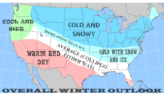
Temperatures:


I expect conditions to be similar to the previous winter but not as brutal with the cold so I am going for colder than average across the Midwest, Great Lakes, the MA and NE. Slightly below temperatures can be found for areas further south for places such as the northern section of the Southeast, parts of the TN Valley, stretching northwest across southwestern MO, KS, southwestern NE, NE CO, parts of WY, and parts of ID. I expect average temperatures (though they can fluctuate) across the Central Rockies down to the parts of the Southern Plains, and through the central portion of the Southeast. I have included the PNW as well, but I believe they can easily become cooler than average considering my thoughts for their overall winter. Slightly warmer than normal temperatures are in store for areas from northern CA, southeast to most of LA, and eastward along the Gulf Coast through much of FL. The warmest of temperatures will be experienced for the rest of the PSW and Desert SW to southern TX where I expect ridging to dominate and southern FL.

Precipitation: (Note: When I say precipitation, I'm referring to both wintry precip and rain potential)


There should be an abundance of precipitation for the PNW and eastward across the Midwest, Great Lakes, MA, and NE. Slightly above average will be featured for the Central Plain States and southeastward across parts of the Lower Ohio Valley and TN Valley, and through the northern section of the Southeast. Average precipitation is in similar place to where I had my temperatures except the PNW due to several storm systems arriving from the Pacific, taking favorable tracks to put down plenty of rain and snow for the higher elevations. Where I have the ridging situated, those areas should experience below average precipitation for the most part but I will not rule out a chance for them to at least reach their average. It only takes a storm or two to put them at average in both rain and snow so that was considered while making this forecast.

Snowfall:


Not much to mention with this map since this would match what I had with my other maps.  I will go over the percentage per area. (Note: I did not put the PNW in the above average snow due to the assumption that the mountainous regions will already see that happening and expect the lower elevations to see rain).

Above Average: 100%-200%
Average to Above Average: 100%+
Average: 100% (Could be slightly above or below)
Below Average to Average: 0%-100% (leaning more toward the low side for that area)

Storm Tracks:


I know it may look a tad confusing with all the lines drawn the way they are, but I will go over each starting with the primaries:

The first one I put down just off the West Coast.  Given the influence felt by the ridge and trough setup, it will travel just southeast of the PNW, throwing plenty of precipitation back their way and then head southeast from there.  Now there are three alternate paths that I think it could take at this point.  It can either jog to the southeast a bit and cut through the Ohio Valley and Southern MA before going OTS, take the same path but turn more northeastward once it's close to WV, or it can dive close to the Gulf Coast and then travel eastward through the Southeast and go OTS.

The next primary track is the Alberta Clipper, which we all should be familiar with.  This go around, however, I believe it can take a further south track due to influence from the -NAO troughing so areas that normally miss out can get in on the action.  There may also be moments where these clippers can get a bit of an attitude and actually pull additional amounts of energy from the south, though I would expect those amounts to be small at best.

The third primary is located down in the GoM where systems can develop and then travel along the coast, becoming the typical Miller A/Nor-easter kind of system.  We all should be familiar with this as well.

Moving on to the secondaries, you will notice I placed two on the map.  One of them is located in northern CA, which I expect tracks like that to take a direct northeastward direction spreading additional precipitation for the PNW and Northern Plains.  I predict this will happen a few times throughout the season.  The second one is down in eastern TX.  Here, a system would develop close to the Gulf and manage to pull plenty of moisture that may be nearby and then take either a direct east route and OTS, possibly jogging slightly northeast as well, head directly through the Carolinas or it may become an Apps Runner and potentially cause a Miller B setup with a coastal low developing nearby.  This particular track could happen a few times as well.

Conclusion:


Overall, this upcoming season is shaping up to be similar to this past winter. Lots of potential for an active Eastern US season even down across the Southeast with several storm threats to watch, not to mention the possibility of a major ice storm. It has been quite a long while since we last had such down here in NC and so we, as well as other areas that are favorable for this, are overdue for one and this winter just may bring it. When that would occur I can't be certain but I would guess it would have to be sometime in January or possibly February when the warmer air has a better chance to nose its way in during a CAD. Speaking of CADs, it's been amazing seeing them pop up so much like they used to years ago and could be a sign of us getting back into that pattern so I foresee periods where a wintry mix of snow, sleet, and freezing is possible across parts of the Carolinas. Going outside from here, I can see the PNW getting copious amounts of rain and snow back their way, keeping the area cool and wet for the most part while the mountainous regions get into the cold and snow. Areas across the MA, NE, GL, and Midwest should once more be in the jackpot for seeing plenty of blizzards and sustain periods of cold, perhaps some very brutal cold entering into those regions during December and again in January. The only area I see not being on the same page with them is the far northeastern corner of the US (mainly Maine) where they will be in their own kind of setup similar to what I expect for the areas in the light blue but with better chances for snow Down across the Southwest and Southern Plains, ridging looks to dominate that area with continued warmth and dryness. It's bad enough for them to have gone through the relentless drought during the summer and fall, and now unfortunately it looks to continue for winter. I'd like to see them be able to get some kind of massive southern storm system that develops and delivers tremendous amounts of rain for them (which I actually think would be possible though not likely); one that cuts directly through all of the Southern portion of the US. Winter, for them, will at least be calm with few chances for snow in the favored areas. I will not rule them out getting into a few periods of below average temperatures, which would be more likely as we progress through February since that's when I would expect the Southeast to finally be influenced more by the ridge and not the trough while the west experiences their pattern change. In short: This will be another exciting winter as we monitor storms, debate about how much snow someone will get, the bone-chilling moments when cold air strikes with vengeance, and most importantly: Your usual model drama and weenies doing their usual cliff dive when the models don't go their way LOL!

Anyway, I want to thank you all for taking the time to read my forecast. I know I'm not one of the best in the world but like I stated earlier, I have put a lot of hard work into this in hopes of getting to express my thoughts about the upcoming winter season. Hope you enjoyed it and remember to prepare yourselves if you are in one of the areas that I expect to see lots of wintry action. Stock up on the non-perishable food, batteries, a generator (if you have the money to spend), water, etc. You know the drill. Don't overdo it if you're shoveling and take frequent breaks. We've had enough folks getting a heart attack from doing too much shoveling all day. Take care everyone.

Thursday, November 3, 2011

Rain and Storms to Move in for Later Today. Another Cooldown for the Weekend

Our vigorous storm system is currently crossing MO with an attending cold front.  As the day progresses, it will gradually become cloudy with showers moving into the region later today with some potential for thunderstorms as we are dealing with plenty of low level convergence/ upper level jet divergence and plenty of moist flow to work with.  Considering the combination of some instability, healthy low level shear, and the focus area for the development of a triple point system, the system can make for what could be a QLCS type of setup during the early morning period.  In this case, this does mean that any storms that do develop have the chance to get a bit of an attitude with a few isolated tornadoes possible but I'm not expecting this to be anything major.  If one were to spin up, it will likely be quite weak and short-lived.  As the cold front passes during the early part of Friday, backside moisture with significant cooling could allow some snow to fall at the highest peaks across the Apps.  Eventually the upper level low that will be sitting on top of the Carolinas will pull away with the surface low and cold front later Friday and allow clearing to kick in.

Ridging will build in as we get into early next week, pushing our temperatures slightly above normal regarding highs (thinking mid 60s to around 70).  Back west, another system will develop and appears that it may be in similar fashion to the one that's getting ready to come through the Southeast.  Surface cold front with plenty of low-level shear and low instability but this appears to have a better chance to produce some severe weather across the MS Valley and areas east, dumping a good bit of rain for the folks over there.  Timing will need to be watched and see if that can materialize successfully  That should progress over to our area during the mid period next week and bring with it more chances for showers and thunderstorms.  Ahead of the front, highs will continue to range in the 60s to around 70, maybe low 70s for some.