Thursday, December 30, 2010

A Bit of Warmth, then Another Wintry Potential

Afternoon everyone.

After seeing several days of below average temperatures, the end of this week will feature temperatures reaching from average to slightly above average as we close off this month and into New Year's.  A great time to do some outdoor activities, whether it be bike riding, jogging, yard work, or simply spending time with the family somewhere without having to worry about bundling up haha.

Of course, the warm up will only last a few days and we will be back to seeing colder conditions again.  In fact, there is already another threat for a potential winter event around the end of the first week of January.  Euro is showing what appears to be a developing system traversing through the SW in the 8-10 day outlook while having a retrograding block.  We also have some pieces of northern energy, so there is a chance that phasing could occur at some point.  Usually in the case of southwestern lows, retrograding ridging occurs in Canada and the cold gets shunted southward and a disseminated baroclinic zone in the Gulf.  Compared to GFS, there is quite a notable difference with how the vortex is handled, and in this case, makes a world of a difference when dealing with UL energy the outcome of an event:
Definitely as we continue on, there will be more data to look at and I will be keeping a close eye on this with the potential.  More to come later.  Have a great day. 

EDIT: 12z Euro looking similar to what it depicted with our last system several days out.  Hmm.......

Sunday, December 26, 2010

A Winter Wonder

As our storm pulls away, we are left with decent snowfall accumulations across much of the state of NC.  Here at my home, I got around 4 inches after some more light snow moved through the CLT region during the early morning hours.  Some places, such as Asheville or Arden, saw nearly 10 inches of snow from the event!  Nicely done for those areas.

Throughout today, we'll struggle to get into the mid 30s.  I expect road conditions to deteriorate as we head into the evening and especially the night hours where temperatures will drop back below freezing and cause a bit of an icy headache for some with the refreezing of roads for the morning commute.  If you have to head out...BE CAREFUL!

No future wintry threats are in the offing as we head into next week, where we'll do a bit of a flip with our weather here.  We'll go from temperatures in the 30s to 60s at New Year's with some possible rainfall!  Amazing how the weather can be in the Carolinas.  It will feel really nice the further south you go, where temperatures could get near 70 in areas such as southern GA.  I don't expect this warm up to last for a long while though, as long range suggests a knock-back to colder temperatures during the first part of January.  Speaking of that, the winter forecasts calling for a mild January could be in danger as the real warm up may end up beginning some time in the middle of January, but even that may need to get pushed if modeling continues to show below average temperatures.  We'll see.  I'm still sticking with mid-January to early February as the warm-up period (NOT a torch but at least slightly above average temperatures) for now.

Hope everyone got what they wanted, though I'm sure a few of you would love to have seen more.  I'm content with my amount so no complaints here.  Have a good day everyone!  Hope your Christmas went well like mine did.

Saturday, December 25, 2010

MERRY (WHITE) CHRISTMAS!

After a stressful week of Christmas business and following a tough to forecast storm system, we finally reach the end of our chaotic road.  I hope all of you take your time today and here's to a wonderful Christmas Day from yours truly.

Now then...Regarding our event, it looks as though the westward trend that I spoke of earlier has occurred, and we are now looking at significant accumulations from this system.  Last I checked, our low was moving through LA with the northern energy diving down behind it.  This will allow a phase to occur in the correct area and really explode the system with moisture as it continues eastward and eventually up the coast.  With the strong dynamics in place, I would expect deformation banding to set up shop somewhere across the foothills/piedmont of NC, and that includes the CLT region as well.  There was also some muttering of possible thundersnow taking place in spots (especially from ATL to Western SC), so those areas could see higher totals easily. I would also not be surprised if stationary banding took place across NC.   Speaking of which, here is what I think will be the totals as of now:


For the mountains, I expect them to see the highest totals given that upslope snows take places along the western edge of the Appalachians, hence the plus I put there.  For most of NC, a general 4-8 can be expect but will not rule out the deformation banding that will be taking place NW of our system, which can make some areas receive that 6-10 in. that I mentioned.  This could also be said for the RAH area, where someone could see up to a foot of snow if they are sitting in the right spot.  As you head further south and east in the state, the totals lessen up due to the possibility of mixing issues with a bit of the WAA (warm air advection) getting involved, so that explains my 1-3 and 3-5 areas.

Keep in mind that with totals like these, the weight of the snow can easily cause tree branches (and consequently cause power lines and other property to be in danger) to snap and possibly weak roofs to collapse.  If you have to drive, BE EXTRA CAREFUL!  I can't stress this enough, especially if you live in the South longer than I have and with this kind of winter storm, the chances of wrecks increase substantially.

Very interesting of how the modeling has been acting regarding their ability to forecast this storm.  We go from storm to no storm and then storm again.  As proven, the Euro was onto this event the entire time since it was first depicted despite losing it mid-week.  Even as I type this, modeling continues to show this storm being slightly stronger than the previous run, so it is shaping up to be a White Christmas to remember and with that said, the accumulations that took place across NC back in 1947 may be in danger of being broken...This only proves my point earlier (for those of you who follows me on Jeff Crum's chat) why you shouldn't take modeling too seriously and this is the result of it haha.  Anyway, enjoy the day with family and friends, play in the snow, and above all, be thankful that God has blessed you with this possible once in a lifetime event.

MERRY CHRISTMAS! :) 

Wednesday, December 22, 2010

Land Ho! Analyzation of Storm Now Commenced

After a busy 2 days of answering questions and watching trends, I finally got an update here haha.  Anyway, we are now within 72hrs. of the upcoming event, and so far, we continue to see trending with most of the models toward the Euro's solution.  GFS definitely took a step forward on the 18z run and even had our low bomb out near the coast, but it is still nowhere near what the Euro had put out.  I know this all sounds exciting and optimistic for a snowy dump, but let me go ahead and say the following...

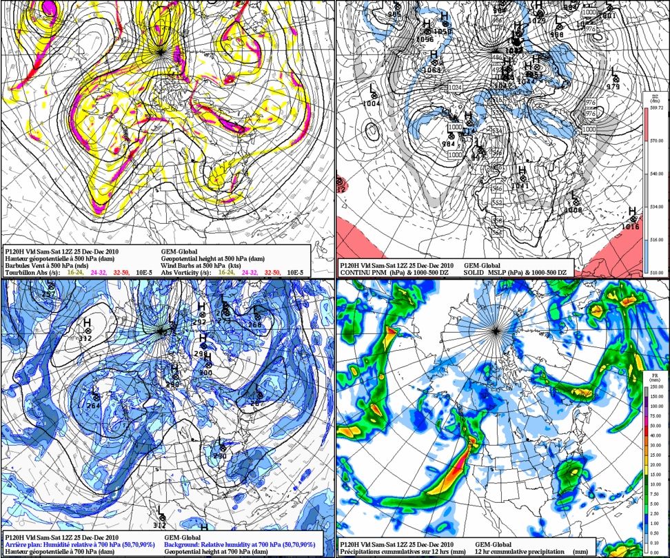
To start off, the system just got onshore, and while it is looking good right now, we still need to hope that this system phases correctly once it starts its trek toward the Deep South.  I cannot stress that enough of how important that part is because you have 3 pieces of energy to work with.  All of them MUST come together at the right place at the right time to get this low really cranking in strength.  If not (whether it phases too early or too late) will completely turn things around in my thinking of our snow totals (which I'll get into in a moment).

Also, there has been some discussion about the system's spin and placement of the track, and these are also important to note.  While the Euro may be depicting this low to be quite powerful, I am somewhat concerned about how tight this thing rotates.  Too much rotation of the precipitation can and will hurt some folks further west when the system begins going along the coast.  By that, I mean for us folks in places such as WNC, we can easily miss out on the majority of the snow while folks further east are getting hammered to death.  As of now, I don't think this will be too much of an issue since I expect the precipitation shield to be quite expansive, but even then, I expect Eastern NC to be the big winner out of this.  Regarding the track, I don't see much in the way of this thing being any further east or west than where it will most likely go right now.  A slight shift further west will cause areas like the Piedmont of NC and Upstate SC to get walloped, as well as dumping some nice accumulations further west like Athens, GA or Bostic, NC.  Further east will end up giving areas like the coast a chance for some moderate to possibly heavier accumulations on their end.  Honestly, I think it can go both ways, but it will be a minor shift since we do have our 50/50 low and PNA ridge to keep this system in check regarding its movement.

As far as accumulations go, I'm going to go ahead and put out the "realistic" amounts that CLT and RDU could see.  I'm going with a general 3-6 inches across our area including Upstate SC and I-40, with RDU getting 6-12 and possibly places further south and north of the area.  Now if you're wondering what accumulations I would put if the Euro's extreme solution verified, here's how I see it.  Areas in and around CLT would be seeing 8-12+ (extra inch or two) and areas in and around RDU seeing 12-20+.  This is assuming that the axis of the heaviest moisture takes place along I-85 and then working eastward becoming wetter while the system deepens and heads NE toward the NC/VA coastal border.

Don't try to get worked up from the accumulations that I've put out, because I (as well as few others like Jeff Crum) caution you that this could still go POOF despite the declining chance of that occurring.  Overall, I am impressed with the trending of some of the modeling and this boosts my confidence level more (65/35).  The event looks to start sometime in the afternoon (night at the latest) and last through Sunday and possibly into early Monday.

That is it for now.  I may have time to put up another update tomorrow.  For now, just keep the following above in mind when looking at our system.  Will we see a historic snowstorm, or will this be minor?  Ma Nature will ultimately decide this...

Tuesday, December 21, 2010

Keeping the Snowy Faith Alive

More terrific news for you snow lovers hoping for a White Christmas.  Here's the breakdown of this situation:

0z Canadian: Continues to hold strong on the snowy concept, but now it appears that this would spell a major snowstorm for parts of the SE.  From hours 96-120, our system is between the borders of MS and AL heading across the central and southern portions of AL and GA at 108 toward the northern section of the SC coast.  A surge of heavier moisture also spreads over the Carolinas as the low continues to strengthen to 1001mb early Sunday.  With the already cold ground temperatures and strong cold air pushing behind this system, it can really set the stage for a truly cold and snowy Christmas later that day Saturday.  Subzero wind chills could also be an issue for folks trying to head out during the night hours.

0z UKMET:  This run of the UKMET takes our system WAY south!  At first it seemed as though it was going to follow what the Euro did, but as soon as it left Texas, the low takes a dive toward Florida.  In fact, it is sitting around 1010mb and west of Tampa Bay at 120hrs.  From there, the low curves up but stays well east of Cape Hatteras.

0z Euro:  This run was no different than its 12z or the Canadian for that matter in terms of what plays out.  Starting at hr. 24, the shortwave comes in strong toward the Southern California area (deja vu, anyone?).  It is a bit south of where the 12z had at 36hrs.  The track of the low continues to be further south as we approach the 48hr. period to the point where it is closed (also continues at 54hrs.).  Our low then positions itself in NW AZ at 60 while still being closed and quite potent as well.  Suddenly, as it approaches NM, the low is directly in the center of the state at 72hrs., but suddenly opens up a little, only to be closed again six hours later.  By the time we reach the 84hr., the low is now in West Texas with an inverted trough through OK and KS while precipitation is falling heavily.  During the 90hr., the closed low's precipitation is about to reach Memphis and eighteen hours later at 114...the phase takes place at the right time and area (so it appears).  By 120, a 1012mb low sits in the Panhandle of FL and suddenly BOMBS in SE GA with snow taking over Western Carolina, VA, and even in ATL!  QPF totals are very impressive (nearly an inch in the CLT region), and temperatures are shaping up to not be an issue whatsoever.  The low by then has become 1000mb near Charleston with snow falling in most of the Carolinas and E GA.

So there you have it.  This has been three times now that the runs (especially the Euro) have shown a significant winter event to occur for our area.  Will it hold for Tuesday and Wednesday?  Time will tale the tell.  My confidence level at this point has raised to 35/65 or 40/60 (Give or take 5.  Left side for yay; right for nay).  Is this all a dream!?  Nah couldn't be...or could it??????  See you on the next update.

Monday, December 20, 2010

The Trend Continues...12z Euro Agreeable to 0z's Solution

Ever since the great run of the 0z Euro, most, if not all of the modeling is now showing similar southerly solutions with the track of our next storm system.  The only one that doesn't seem to go as far south is the OP run of 12z GFS, but even that one trended a bit further south. As for the rest of the 12z runs, the Canadian, 12z GFS ENS, and UKMET are all showing that southward trend that the Euro did but not as robust with the system.

12z Euro came in very similar to its 0z run.  Our system takes nearly the exact same track (From Mobile toward and along the NC coast).  Our 850 temperatures are also a bit colder as well, so that's a plus (3°C colder to be precise).  The low sits just a bit east of Mobile AL at 120hrs., really deepening itself as it gets ready to make a run in a NE direction.  At 144hrs., the low is sitting at 996mb around Cape Hatteras, so eastern NC is getting nailed at that point.  Temperatures are below freezing as well across the CLT region (ranging mid-upper 20s).  Despite the .50-.75 qpf totals, none of us should worry about that since we're a few days away from the event,  but even if it was to be a bit of an issue, the snow ratios are looking decent enough that you can get several inches of snow.  Overall, I'm impressed that this run came in the way it did.  Not completely excited yet, but we have a lot of the table that's coming together for a decent chance of a White Christmas across parts of the SE
 
Canadian 12 hr. cumulative precipitation (120hrs.) : http://www.americanwx.com/bb/uploads/monthly_12_2010/post-25-0-60598300-1292865039.jpg

Canadian P-type at 120hrs.: http://collaboration.cmc.ec.gc.ca/cmc/cmdn/pcpn_type/2010122012/I_nw_g1_EST_2010122012_114.png

12z GFS ENS: http://raleighwx.americanwx.com/models/gfsensemble/12zgfsensemblep12120.gif

12z Euro (120 and 144):  http://raleighwx.americanwx.com/models/euro/12zeuro850mbTSLPUS120.gif
http://raleighwx.americanwx.com/models/euro/12zeuro850mbTSLPUS144.gif

♪ I'm Dreaming of a White Christmas ♪

Now then...I hope you have something to keep yourself from fainting, because you will not believe what has occurred from the 0z Euro. Ready? Here's how its solution came out (try not to get too excited)...

We have a strong closed shortwave that enters southern California 72hrs. out from now. At 84, it is in central AZ while still closed and holding strong (Already well south of GFS). Later on before 90 hrs. out, a 1036 high develops and heads SE, spilling quite a bit of cold into the US while still being NE of the storm system. Our low is still quite south, spreading snows across the Plains and rainfall in Texas at 96hrs. This look still persists later at 102 hrs., so it's doing excellent at this point. Looking at hr. 108, the low has shifted even more south, which makes it enter Dallas and the high pressure continuing to slide SE while an inverted trough goes through MO. At this time, major ridging occurs in Western Canada, which helps amplify our shortwave.  From 114-120, the surface low has traveled into central LA and is sitting in areas between Mobile, AL and Jackson, MS. Snow falls in N. GA and all of TN at 126 hrs. (phasing occurs in SE MS). Finally, the heights crash to the point where everyone that is north of the low is changing to all snow at 132 hrs. at 1008mb in the FL Panhandle. For the last bit of explanation, our system sits at 1000mb on the NC coast in Myrtle Beach, spreading snow back across the Carolinas, GA, VA, and even back towards E KY at 144hr.!

Okay. You can calm down now. How's that for a thought? If this verified, this would be the first time in several years that the CLT region, let alone most of the SE, has seen a true White Christmas! Unfortunately, since this is being shown 5 days out, it's liable to get lost assuming the odds are against us, but who knows? This year JUST MIGHT break it. We shall all see what happens in the end. Rain, ice, snow, or any mix of the three? Ma Nature will decide that fate. *Cues dramatic music*

120: http://raleighwx.americanwx.com/models/euro/00zeuro850mbTSLPUS120.gif
144: http://raleighwx.americanwx.com/models/euro/00zeuro850mbTSLPUS144.gif

Sunday, December 19, 2010

Update on Christmas Storm (0z GFS, CMC, and UKMET) Plus a Few Words of Winter Wisdom

By the way, from what I have gathered from the 0z GFS, track of the system looks to be just a tad further south. Our storm fails to phase with the northern stream and instead gets sheared and goes up the coast after its visit in NC. The WAA takes effect and kicks all of NC over to rain, and then CAA replaces it after the cold front passes through. The only positive was that our blocking is stronger but not by much, but that was the cause of the shearing of this system when it was pushed further SE into the Apps. By the time it passes the Apps, there is only a bit of moisture left and temperatures are not supportive for anything frozen since the cold air is chasing the moisture. Overall, it is a MUCH better look than 18z GFS with its solution of the storm track.

The Canadian came in nicely for most of the areas affected, but for areas such Upstate SC and the Southern Foothills of NC, there is less precipitation occurring. Nonetheless, it looks good for at least the majority of NC. Off to a good start with that run. UKMET was similar in its solution; both tracks from the modeling a bit further south than 0z GFS.

The one thing we need to watch from run to run is where the 5H is when it enters S. California. From there, it's a matter of whether or not we can get the northern stream to phase with it, and that will have implications down the road. I mentioned earlier on the chat how the 50/50 low is very important to look for as well. We already have the -NAO and if the PV cooperates, you can really get something good going but it would also be nice to have our PNA be positive instead of our current negative one. That causes ridging in the west instead of having a fast flat flow, resulting in allowing systems to dig further south.

Here's a link to learn about the 50/50 low if you like to read more about it: http://www.liveweatherblogs.com/weatherblog/15481/-----What-The-50-50-Low-Has-To-Do-With-Our-Snow-Storm-Potential---

My First Post

Hello everyone. You all know who I am if you have been on News 14's chief meteorologist Jeff Crum's chat. My reasoning for creating this blog is to keep from having to worry about my posts on the chat appearing as potential spam, and to generally give my thoughts about the weather, be it winter, severe, and or even calm conditions. I hope you all enjoy reading my posts, and I will try to update as soon as possible on any special events that affect the SE US. Thank you! :)