Hope everyone found a way to enjoy yesterday's damp and chilly conditions as we finally see this ugly mess lift away from our region across the SE for the rest of the early morning hours. An arrival of colder air filters into the area for the rest of this week, knocking us back into the much colder temperatures for the night time period of the 20s and possible upper teens as a range of lows around Saturday.
What looked good for a possible wintry event this late week has since vanished from the modeling and looks more likely that we experience nothing but a chance for some passing showers for the Thursday night-Friday morning time frame. Once that clears out, our attention will be toward what occurs for next week. Based on recent data, here's the breakdown:
0z GFS: Once more, we see another oddball job pulled off with this run. Going out to the 120 hr at 500mb, the setup it shows is fantastic for something interesting across the SE. The vort energy has a very healthy look to it back in the southwestern states and digs a good bit southward while progressing east. Jumping to the 192 hr, that energy has reached central TX with a neutral trough already established and staying intact. However, that energy gets dampened out as soon as it leaves TX and thus you see a garbage output with the surface plots not matching the upper air features at all. This is just like the time that the NAM was having an issue matching its 700mb/omega feature with its 850mb plots for our past winter event. At this point, I wouldn't throw away the 0z completely despite its screw up but keep an eye on the 5H level. If we see a continuing trend with the model extending the life of the vort energy (and if the surface plot correctly reflects this), it will be something to take into consideration in the near future.
0z GGEM: This was also a great run for us. Here the Canadian is able to handle a couple of waves of energy correctly (again at 500mb). With the primary wave, this one moves into central TX and then travels across the southern part of MS and into central/northern AL while still remaining healthy. In turn, upper level cooling can take place and snow becomes more likely for areas north of the surface low as it travels along the Gulf Coast.
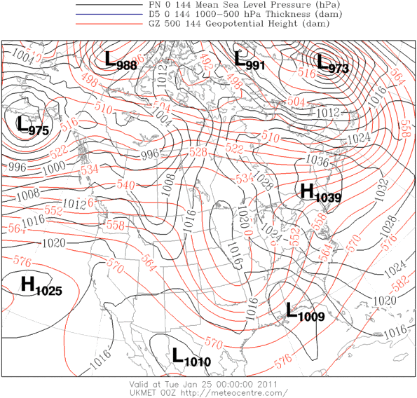
0z UKMET: Also comes in robust with our system but threatens areas such as the Carolinas and north GA with a damaging ice storm at the cost. You have a 1039mb high in the NE in NY with a low at 1009mb sitting between the borders of MS and AL on Tuesday. Places east of the Appalachians would need to watch out if this solution verified but will not wig out about it on this model. However, the Euro says this as well but will get to that part on the next section.....
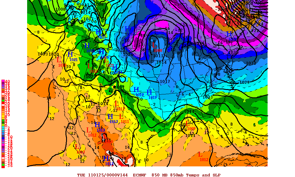
0z Euro: As stated, pretty much an eerily similar setup shown on here like the UKMET but first, I will point out what has showed up for Sunday. Starting out at the 72 hr., our system is exiting southeastern TX and moving across the Gulf Coast strengthening some as it does so and actually spreading what looks like a bit of snow across the Arklatex area and northern MS/AL/GA. By 96, this low has become 1000mb and curves NE after exiting FL but not hugging the coast. However, it is close enough that areas along the SC/NC coast could get in on some snow for their area. Any closer to or along the coast and areas further west like us will need to start watching but right now this is more of "Coastal Special" verbatim of the Euro. QPF totals suggest nearly .70 for Wilmington (the winner) and the Pitt-Greenville Airport area with only .09 (the loser). After this, we relax for a day before worrying about the next system to push in. This is where the similarity between it and the UKMET comes into place, with nearly the same strength and placement of the damming high (1038mb), as well as the low:
UKMET: http://i715.photobucket.com/albums/ww152/Killerchaos7/UKMET.gif?t=1295424474
EURO: http://i715.photobucket.com/albums/ww152/Killerchaos7/EURO.gif?t=1295424476
In this case, the Euro would also suggest an icy doom for parts of the SE, with everyone starting as snow and then changing to ice as temperatures aloft warm some. This would imply that from say NE GA to Western/Central NC would see the worst of this scenario. I would pay special attention to the 5H with this one because if it holds on the next several runs, then we have ourselves a major problem to deal with. I wouldn't worry about the 850s or how much moisture, but just keep an eye on the 500mb charts when you get the chance to view them. It can easily change on the 12z and is also out to at least a week, so there is not much to worry about for now thankfully. Could trend colder/snowier, warmer/wetter, etc. but I just can't give a definite answer until we're closer.
Overall, one can say that the trend was colder and potentially more wintry on all of the models that I just summarized. One thing that I will say is to keep watching what happens back west with our shortwave, and pay attention to how much it digs and whether or not it stays unblemished. That will be key as to what we in the SE could see for next week. It will be a rough ride indeed and chances are, MUCH CAN AND WILL CHANGE between now and the next 7 days. As always, I will keep an eye for you folks on this ever-changing situation and will get back to you all if I can. Take care.
No comments:
Post a Comment